Port Clinton
| Port Clinton | |
|---|---|
 |
|
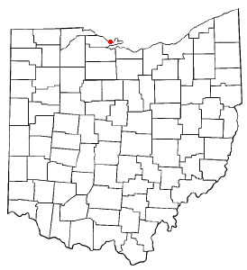
| Location in Ohio | |
| Basic data | |
| State : | United States |
| State : | Ohio |
| County : | Ottawa County |
| Coordinates : | 41 ° 31 ′ N , 82 ° 56 ′ W |
| Time zone : | Eastern ( UTC − 5 / −4 ) |
| Residents : | 6,056 (as of 2010) |
| Population density : | 1,121.5 inhabitants per km 2 |
| Area : | 5.9 km 2 (approx. 2 mi 2 ) of which 5.4 km 2 (approx. 2 mi 2 ) is land |
| Height : | 177 m |
| Postcodes : | 43446, 43452 |
| Area code : | +1 419 |
| FIPS : | 39-64150 |
| GNIS ID : | 1061564 |
| Website : | www.portclinton.com |
| Mayor : | Vincent Leone |
Port Clinton is a city in and the administrative seat of Ottawa County in Ohio , United States of America with a good 6000 inhabitants.
The place is on the Marblehead Peninsula at the mouth of the Portage River in Lake Erie . The local Carl R. Keller Field Airport has the IATA code PCW .
geography
Port Clinton's geographic coordinates are 41 ° 31 ' N , 82 ° 56' W (41.509857, −82.940156).
According to the United States Census Bureau , the city has a total area of 5.91 km², of which 5.39 km² is land and 0.52 km² is water.
Demographics
| Population development | |||
|---|---|---|---|
| Census | Residents | ± in% | |
| 1850 | 249 | - | |
| 1870 | 543 | - | |
| 1880 | 1600 | 194.7% | |
| 1890 | 2049 | 28.1% | |
| 1900 | 2450 | 19.6% | |
| 1910 | 3007 | 22.7% | |
| 1920 | 3928 | 30.6% | |
| 1930 | 4408 | 12.2% | |
| 1940 | 4505 | 2.2% | |
| 1950 | 5541 | 23% | |
| 1960 | 6870 | 24% | |
| 1970 | 7202 | 4.8% | |
| 1980 | 7229 | 0.4% | |
| 1990 | 7106 | -1.7% | |
| 2000 | 6391 | -10.1% | |
| 2010 | 6056 | -5.2% | |
| 2014 estimate | 6009 | -0.8% | |
| Swell: | |||
Personalities
- George Ege (1748–1829), metal manufacturer
Web links
Commons : Port Clinton, Ohio - Collection of pictures, videos, and audio files
Individual evidence
- ↑ Port Clinton ( English ) In: Geographic Names Information System . United States Geological Survey . Retrieved August 8, 2015.
- ↑ US Gazetteer files: 2010, 2000, and 1990 ( English ) United States Census Bureau . February 12, 2011. Retrieved April 23, 2011.
- ↑ US Gazetteer files 2010 ( English ) United States Census Bureau . Archived from the original on February 20, 2011. Retrieved January 6, 2013.
- ↑ Annual Estimates of the Resident Population for Incorporated Places: April 1, 2010 to July 1, 2014 ( English ) Retrieved June 4, 2015.
- ↑ Population of Civil Divisions Less than Counties ( English , PDF) In: Statistics of the Population of the United States at the Tenth Census . US Census Bureau. Retrieved on November 28, 2013. ( Page no longer available , search in web archives ) Info: The link was automatically marked as defective. Please check the link according to the instructions and then remove this notice.
- ↑ Population of Civil Divisions Less than Counties ( English , PDF) In: Statistics of the Population of the United States at the Tenth Census . US Census Bureau. Retrieved November 28, 2013.
- ↑ Population: Ohio ( English , PDF) In: 1910 US Census . US Census Bureau. Retrieved November 28, 2013.
- ↑ Population: Ohio ( English ) In: 1930 US Census . US Census Bureau. Retrieved November 28, 2013.
- ↑ Number of Inhabitants: Ohio ( English , PDF) In: 18th Census of the United States . US Census Bureau. Retrieved on November 22, 2013. ( Page no longer available , search in web archives ) Info: The link was automatically marked as defective. Please check the link according to the instructions and then remove this notice.
- ^ Ohio: Population and Housing Unit Counts ( English ) US Census Bureau. Retrieved November 22, 2013.
- ↑ Incorporated Places and Minor Civil Divisions Datasets: Subcounty Population Estimates: April 1, 2010 to July 1, 2012 ( English ) US Census Bureau. Accessed in 2013-11-2015.
