Olenhusen
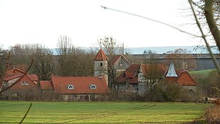
Olenhusen is a district of Settmarshausen , municipality of Rosdorf , in southern Lower Saxony . It mainly consists of the Olenhusen manor , a formerly fortified rural aristocratic seat of the Götz von Olenhusen family named after him .
Geographical location
Olenhusen is located in the Grundbach valley at the confluence of the Lohbeke at about 200 m above sea level. NN . The manor buildings are located between the Grundbach and Kreisstraße 34 from Rosdorf to Settmarshausen, to the north of the street are several other buildings in the district. Neighboring towns are Tiefenbrunn in the southeast, Settmarshausen in the west and Groß Ellershausen in the north.
history
The first written mention of the place "Olenhus" from the time between 826 and 876 is handed down in the Traditiones Corbeienses , another from the time between 976 and 979 under the name "Olonhusun". The place name goes back to the personal name Olo in connection with the frequent ending -hausen . An assignment to a military leader named Olo of the Frankish king Chlothar I on his Saxon trains in the 6th century, to whom Chlothar gave the village he founded, can only be regarded as a guess. Other authors give a mention in 1318 as the first mention, when Duke Otto der Milde lent six Hufen land in Olenh (usen) to Gunter von Boventen . Also in 1403 the Lords of Boventen owned the hove tzu Olenhusen and syner tzubehoringe .
In a document dated May 17, 1414, Hans von Boventen and his three sons Borchard, Heinrich and Gunter allow the city of Göttingen to build a stone observation tower on his land above the Oylenhusen farm . The control room was on the Wartberg about 800 meters north of Olenhusen, where the former military and trade route ran from Göttingen to Münden , and was included in the Göttingen Landwehr system.
A comparison of the area of the lands of the later estate of around 20 Hufen field field and 8.5 Hufen forest in 1850 with the 6 Hufen of the court of the Lords of Boventen mentioned, as well as the place name, could indicate that Olenhusen was originally not only from a large one Hof existed, but was a village with several courtyards, the lands of which were later incorporated into the aforementioned courtyard at an unknown point in time. Olenhusen is therefore sometimes referred to as partial desertification , like other villages that have been absorbed into an estate or monastery . The last lord of Boventen, Ludwig, sold his fiefdom with the bailiwick rights in Olenhusen in 1578 to Joachim Götz , a follower of Duke Erichs the Younger . On July 13, 1591, Emperor Rudolf II conferred hereditary nobility on him under the name of Götz von Olenhusen . In 1588 Joachim Götz von Olenhusen acquired part of the fields of the deserted neighboring village of Sidershusen from the city of Göttingen, initially as a pledge. After a dispute with the Göttingen citizen Veltmann, who also wanted to acquire the Siedershäuser Grund in addition to the fiefdom on the 3.6 kilometers southwest of the hot valley , Götz von Olenhusen bought the fiefdom on the Siedershäuser Grund from the city of Göttingen. In 1663 his descendants also bought the fiefdom at the hot valley. The manor Olenhusen was politically part of the Münden office and was then moved to the Leineberg court in 1743. In 1832 it became the Göttingen office . The jurisdiction for minor offenses was in the hands of the landlord until Olenhusen came to the Friedland District Court with the abolition of patrimonial jurisdiction in 1851 , which was then merged with the Reinhausen District Court in 1859 . The Götz von Olenhusen family had been running the estate on their own since 1838. In 1855 the property became free property of the Götz von Olenhusen family when the fiefs were removed. In 1885, a manor district of Olenhusen was formed, which in 1928 was assigned to the then independent community of Settmarshausen, just like the hot valley. Towards the end of the Second World War, part of the manor building was destroyed by artillery fire, including the manor house with the manor chapel.
The Olenhusen settlement now includes several younger residential and farm buildings in addition to the manor surrounded by a wall.
Culture and sights
grange
The listed manor is a specialty in southern Lower Saxony with its rudimentary preserved, probably medieval fortification wall and the various buildings from different construction periods. From the mansion only about 13 meter high circular staircase tower remains, which has since shaped the image of Gutsanlage and earlier might as smaller dungeon served. In addition, the half-timbered chapel, built in 1856, is also worth mentioning, into which part of the former fortification wall is integrated. Next to it is the approximately three meter high stump of a fortification tower. The park belonging to the estate was probably created in the 18th century and has a size of about four acres . The neighboring wooded slope is also designed like a park, there is the hereditary burial of the Götz von Olenhusen family, built in 1893. Part of the former Landwehr of the city of Göttingen has been preserved as a double moat in the manor park. The manor is not open to the public.
Walking and cycling
To the north and northwest of Olenhusen, 600 meters away, the Weser-Harz-Heide-Radfernweg leads past the former railway line of the Dransfelder Rampe . The student path (long-distance hiking trail X13) from Kassel to Göttingen passes 750 meters south of the estate .
Economy and Transport
Today, in addition to the residence of the Götz von Olenhusen family, Gut Olenhusen also houses a riding facility. The settlement is connected to the neighboring towns of Settmarshausen and Rosdorf via Kreisstraße 34, and another road connects to Groß Ellershausen. Olenhusen is connected to the local public transport network via bus route 131 of the Southern Lower Saxony transport association from Mengershausen to Varmissen.
Individual evidence
- ↑ Kirstin Casemir, Uwe Ohainski, Jürgen Udolph: The place names of the district of Göttingen . In: Jürgen Udolph (Hrsg.): Lower Saxony Place Name Book (NOB) . Part IV. Publishing house for regional history, Bielefeld 2003, ISBN 3-89534-494-X , p. 305 f .
- ↑ a b Günther Meinhardt: Chronicle of the community Rosdorf and its localities . tape 1 : From the beginnings to 1933. Wartberg Verlag, Gudensberg-Gleichen 1988, ISBN 3-925277-14-5 , p. 265-270 .
- ↑ a b c Peter Ferdinand Lufen: District of Göttingen, part 1. Altkreis Münden with the communities of Adelebsen, Bovenden and Rosdorf . In: Christiane Segers-Glocke (Hrsg.): Monument topography Federal Republic of Germany. Architectural monuments in Lower Saxony . tape 5.2 . CW Niemeyer, Hameln 1993, ISBN 3-87585-251-6 , p. 241 f .
- ↑ a b Erhard Kühlhorn: The medieval desolations in southern Lower Saxony . In: Publications of the Institute for Historical Research at the University of Göttingen . tape 3 O - Z. Verlag für Regionalgeschichte, Bielefeld 1995, ISBN 3-89534-133-9 , 275 Olenhusen, p. 57-59 .
- ↑ a b c Heinrich Lücke: Castles, official seats and manors around Göttingen . 2nd Edition. Clausthal-Zellerfeld 1969, Olenhusen, p. 297-310 .
- ^ Gustav Stölting, Börries Freiherr von Münchhausen : The knightly estates of the principalities of Calenberg, Göttingen and Grubenhagen , Hannover 1912, pp. 308-316
- ↑ Olenhusen riding facility. (No longer available online.) Bettina Geschke, archived from the original on June 11, 2010 ; Retrieved August 13, 2010 . Info: The archive link was inserted automatically and has not yet been checked. Please check the original and archive link according to the instructions and then remove this notice.
- ↑ VSN timetable line 131. (PDF) Verkehrsverbund Süd-Niedersachsen GmbH (VSN), accessed on August 13, 2010 .
Coordinates: 51 ° 30 ' N , 9 ° 51' E


