Olsa (Metnitz)
|
Olsa Olsabach |
||
|
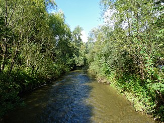
The Olsa near Wildbad Einöd. |
||
| Data | ||
| location | Murau district , Styria ; Sankt Veit an der Glan district , Carinthia , Austria | |
| River system | Danube | |
| Drain over | Metnitz → Gurk → Drau → Danube → Black Sea | |
| source | Arises in Neumarkt from the confluence of Perchauerbach and Hofer Dorferbach 47 ° 4 '39 " N , 14 ° 25' 37" O |
|
| Source height | 850 m above sea level A. | |
| muzzle | In Friesach near the town of Grafendorf in the Metnitz coordinates: 46 ° 56 ′ 31 ″ N , 14 ° 25 ′ 30 ″ E 46 ° 56 ′ 31 ″ N , 14 ° 25 ′ 30 ″ E |
|
| Mouth height | 630 m above sea level A. | |
| Height difference | 220 m
|
|
| Catchment area | 198.5 km² | |
| Discharge at the Guldendorf A Eo gauge : 161.8 km² Location: 6.2 km above the mouth |
NNQ (03.06.1998) MNQ 1994–2011 MQ 1994–2011 Mq 1994–2011 MHQ 1994–2011 HHQ (08.01.2001) |
230 l / s 720 l / s 1.57 m³ / s 9.7 l / (s km²) 12.6 m³ / s 18.6 m³ / s |
| Small towns | Friesach | |
| Communities | Neumarkt in Styria, Friesach | |
| Navigable | No | |
The Olsa , also: Olsabach , is a left tributary of the Metnitz . It emerges in Neumarkt in Styria from the confluence of the Perchauerbach and Hoferdorferbach rivers.
To the south of Neumarkt it flows through the gorge, a gorge-like valley cut and then on through a mostly narrow valley. Shortly before Wildbad Einöd it takes the Pöllauer Bach on the right. In front of Dürnstein there is a small hydropower plant with a 400 m long diversion . Under the striking Dürnstein ruins , the narrow valley opens out into the Friesacher Feld. On the Friesacher Feld it enters Carinthia, and after another five kilometers it flows into the Metnitz.
The name Olsa is Slavic and is interpreted as Erlenbach , in Alpine Slavic olьša (in modern Slovenian: jelša ).
Individual evidence
- ↑ Obvious from the relief view of the source on Google Maps , cf. https://www.google.de/maps?q=47.077469,14.426875&t=p&z=15
- ↑ BENTHIC EVIDENCE OF OLSA IN GULDENDORF AND GRAFENDORF. Carinthian Institute for Lake Research, p. 6 , accessed on April 4, 2013 .
- ↑ Obvious from the relief view of the mouth on Google Maps , cf. https://www.google.de/maps/place/46%C2%B056'30.6%22N+14%C2%B025'29.8%22E/@46.941839,14.424942,17z/data=!3m1!4b1!4m2! 3m1! 1s0x0: 0x0
- ↑ Federal Ministry of Agriculture, Forestry, Environment and Water Management (Ed.): Area directory of the Austrian river basins: Draugebiet. Contributions to the hydrography of Austria, issue No. 59, Vienna 2011, p. 74 ( PDF; 3.5 MB )
- ↑ Federal Ministry for Agriculture, Forestry, Environment and Water Management (Ed.): Hydrographisches Jahrbuch von Österreich 2011. 119th Volume. Vienna 2013, p. OG 346, PDF (12.9 MB) on bmlrt.gv.at (Yearbook 2011)
- ↑ Olsabach - From Marktbach to urban climate. (PDF; 444 kB) (No longer available online.) In: NaturLese-Instruction: Via Natura Stage 1 - Learn to read nature. P. 5 , archived from the original on March 12, 2014 ; Retrieved April 4, 2012 . Info: The archive link was inserted automatically and has not yet been checked. Please check the original and archive link according to the instructions and then remove this notice.
- ^ Water management: GEOS Consulting ZT-GmbH. (No longer available online.) In: geos.at. Archived from the original on November 12, 2016 ; accessed on November 12, 2016 . Info: The archive link was inserted automatically and has not yet been checked. Please check the original and archive link according to the instructions and then remove this notice.
- ↑ Annual Report 2004. Carinthian Institute for Lake Research , p. 30 , accessed on November 12, 2016 .
- ↑ The survival of slaw. * Olьša in Austrian names. (PDF) In: onomastik.at. P. 1 , accessed on November 6, 2016 .
- ^ Report of the Department of State History - Research Project - On the City History of Friesach . In: Kärntner Landesmuseum (Ed.): Rudolfinum . 2002, p. 203 ( PDF on ZOBODAT [accessed on November 6, 2016]).
