Ortahisar (Nevşehir)
| Ortahisar | ||||
|
||||
| Basic data | ||||
|---|---|---|---|---|
| Province (il) : | Nevşehir | |||
| District ( ilçe ) : | Urgup | |||
| Coordinates : | 38 ° 37 ' N , 34 ° 52' E | |||
| Height : | 1200 m | |||
| Residents : | 14,262 (2015) | |||
| Telephone code : | (+90) 384 | |||
| Postal code : | 50650 | |||
| License plate : | 50 | |||
| Structure and administration (as of 2016) | ||||
| Mayor : | İsmail Genç ( MHP ) | |||
| Website: | ||||
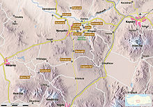
Ortahisar ( German middle castle ) is a small town in the district of Ürgüp in the Turkish province of Nevşehir in the Cappadocia region . Ortahisar has 14,262 inhabitants (as of 2015) and is located about 20 km east of the provincial capital Nevşehir .
Site and sights
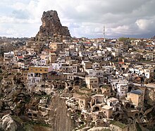
The outstanding feature and main attraction of the place is the approximately 90 m high castle rock, which is also called Sivrikoya by the inhabitants . It is criss-crossed in the type of caves and passages typical of the Cappadocia region , which served the population in Byzantine times as protection from attackers. In the village is the Cambazlı Kilise (acrobatic church) , a cross-domed church with paintings from the 13th century, which is now used as a storage room. Just outside is a rock cone with the Üzümlü Kilise (grape church) from the eighth or ninth century. It has frescoes with grapes and in the apse a picture of the enthroned Mary with child.
In addition to the castle rock in the center of the village, Ortahisar is mainly characterized by a series of simple buildings. These buildings are very similar in architecture and appearance. The older houses are built from blocks of tuff that were mostly joined together without mortar. These buildings, which in earlier times only served as a storage place for food, usually only have one or two floors. The upper floor is often reached via a banisterless external staircase made of tuff stone slabs. The newer buildings are always made of the same type of stone, but actually have walls. The outer walls are clad with white limestone and have simple cornices.
To the northeast of Ortahisar is the Hallaç Manastırı monastery complex. Its center is a courtyard that is closed on three sides and opens to the south. Due to the accumulated rock residue, its level has increased by one and a half meters over time, so that the entrances to the monastery rooms are now lower than the courtyard. After the monastery was abandoned, locals walled up the entrances and framed the windows in color to use them as dovecotes for the production of the bird droppings, which are coveted as fertilizer.
The churches of Sarica and Harum are in the vicinity of the village . Not far from the residential area of Uçhisar are the rocky mountains that almost completely surround the place.
economy
Ortahisar is the center of fruit growing in Cappadocia. The tufa caves in the area, which have a temperature of around ten degrees in both summer and winter, are used as storage rooms for fruit and vegetables, not just for the products of the region. Citrus fruits, potatoes, apples or onions are brought there from all over Turkey, stored in the caves and later transported on. Large parts of Turkey, but also Europe, are supplied from there.
literature
- Peter Daners, Volker Ohl: Cappadocia . Dumont, 1996, ISBN 3-7701-3256-4 .
- Michael Bussmann / Gabriele Tröger: Turkey . Michael Müller Verlag 2004 ISBN 3-89953-125-6 .
- Marianne Mehling (Hrsg.): Knaur's cultural guide in color Turkey . Droemer-Knaur 1987 ISBN 3-426-26293-2 .


