Paisley (Oregon)
| Paisley | |
|---|---|
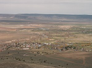
 In the foreground paisley |
|
| Location in Oregon | |
| Basic data | |
| Foundation : | 1911 |
| State : | United States |
| State : | Oregon |
| County : | Lake County |
| Coordinates : | 42 ° 42 ′ N , 120 ° 33 ′ W |
| Time zone : | Pacific ( UTC − 8 / −7 ) |
| Residents : | 247 (as of: 2000) |
| Population density : | 224.5 inhabitants per km 2 |
| Area : | 1.1 km 2 (approx. 0 mi 2 ) of which 1.1 km 2 (approx. 0 mi 2 ) is land |
| Height : | 1330 m |
| Postal code : | 97636 |
| Area code : | +1 541 |
| FIPS : | 41-56250 |
| GNIS ID : | 1147356 |
| Website : | cityofpaisley.tripod.com |
Paisley is a small town in Lake County in the US state of Oregon . Paisley is 1330 m above sea level and has about 260 inhabitants. The place became known through the excavations at the nearby Paisley Caves .
People lived here more than 10,000 years ago. Evidence of this is found in caves and rock paintings. The Indian tribes Northern Paiute , Modoc and Klamath settled here . The Klamath Indians gave the river that flows through Paisley the name Chewaucan .
In 1843 John C. Frémont was a cartographer for the army with his trek on the Oregon Trail . He gave names to geographical features in the area around Paisley such as Summer Lake .
In the early 1870s, settlers arrived in the Chewaucan area, now called Paisley. Lake County became a county in 1875 .
Since 1984 the Paisley Mosquito Festival has been held every year on the last weekend in July, with mountain bike and horse races as well as handicrafts and art exhibitions. There is a historic western saloon in Paisley.
