Panajachel
| Panajachel | ||
|---|---|---|
|
Coordinates: 14 ° 44 ′ N , 91 ° 10 ′ W Panajachel on the map of Guatemala
|
||
| Basic data | ||
| Country | Guatemala | |
| Department | Sololá | |
| City foundation | Pre-Columbian | |
| Residents | 11,200 | |
| Detailed data | ||
| Waters | Lake Atitlán | |
| Time zone | UTC −6 | |
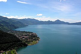
| View of Panajachel | ||
| Calle Santander, the main tourist street of Panajachel | ||
Panajachel (full name San Francisco Panajachel ) is a city of about 11,000 inhabitants in the Sololá department in southwest Guatemala .
Panajachel is located in the central highlands of Guatemala on Lago de Atitlán at a good 1,500 meters above sea level and is now one of the country's tourist centers alongside Antigua Guatemala and Quetzaltenango .
history
The city emerged from a pre-Columbian settlement of the Cakchiquel - Maya . Panajachel gained importance as a theater of war: It was here in 1523 that the last battle of the Tzutuhil Mayas, also based on Lake Atitlán, took place against the Spanish conquerors under Pedro de Alvarado and the Cakchiquel Mayas who were already allied with them. The Spanish conquistadors built a church , founded a monastery and made Panajachel a center of Roman Catholic missionary work for the indigenous population. The facade of the church, built in 1567, is still preserved.
Panajachel owes its current importance as an important trading center on Lake Atitlán to tourism .
Museums
- Museo Lacustre del Lago de Atitlán: The archaeological museum deals with finds of a sunken city from the Mayan period between 1200 BC. And 250 AD at the bottom of the lake.


