Pashuk glacier
| Pashuk glacier | ||
|---|---|---|
|
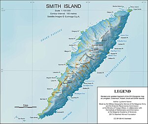
Map of Smith Island with the Pashuk Glacier (center) |
||
| location | Smith Island , South Shetland Islands | |
| Mountains | Imeon Range | |
| length | 2.7 km | |
| width | Max. 0.6 km | |
| Coordinates | 62 ° 59 ′ 45 ″ S , 62 ° 30 ′ 0 ″ W | |
|
|
||
| drainage | Bransfield Street | |
The Pashuk Glacier ( Bulgarian ледник Пашук lednik Paschuk ) is a steep, 2.7 km long and 600 m wide glacier on Smith Island in the archipelago of the South Shetland Islands . On the southeast side of the Imeon Range, it flows from the Vakarel Saddle between the side ridges of the Antim Peak and Evlogi Peak south of the Kriwodol Glacier and north of the Rupite Glacier in a south-easterly direction to the Bransfield Strait .
Bulgarian scientists mapped it in 2009. The Bulgarian Commission for Antarctic Geographical Names named it in 2010 after the Canadian sailing yacht skipper Keri Pashuk, who with his Northanger provided logistical support for the first ascent of Mount Foster by the team around New Zealander Greg Landreth.
Web links
- Pashuk Glacier in the Composite Gazetteer of Antarctica (English)

