
Paslı
Coordinates: 36 ° 28 ′ 4 ″ N , 34 ° 0 ′ 21 ″ E


Paslı (also Papasly or Papazlı ) is the Turkish name of a Roman town in the Silifke district of the Turkish Mersin province . The ancient name of the small town is not known.
location
Paslı is located on a mountain spur above the eastern slope of the Yenibahçe Valley ( Yenibahçe Deresi in Turkish ), which stretches from the Mediterranean near Atakent to the north into the mountain landscape, past the village of Yenibahçe . The distance from Atakent is eleven kilometers by road, and ten kilometers as the crow flies from the district town of Silifke. At the eastern exit of Atakent, a road branches off from the coastal road D-400 to the north, which leads via Türkmenuşağı to Paslı and from there, past the Roman ruins of Tekkadın via Keşlitürkmenli to Uzuncaburç ( Olba and Diokaisareia ). At the ruins of Paslı, another road branches off, which leads to the temple tomb Mezgit Kalesi . On the opposite side of the Yenibahçe Gorge is the Barakçıkale ruin complex .
description
The remains of the ancient small settlement cover an area of about 150 × 200 meters, on which more than 40 houses are distributed according to no recognizable pattern. The oldest of them are built in polygonal blocks with bosses and can be dated to the late Hellenistic period. The youngest are made of polygonal masonry and large ashlars and date from the Roman Empire . The small cuboid structure typical of the early Byzantine period does not appear, even if crosses can be seen on some lintels.
A probably late Hellenistic wall running from west to east divides the place into two sections. It has two shells with a filling of stone grist and clay and has a door 1.30 meters wide. Its purpose is not clear. The greater part of the settlement is south of it. At the eastern end of the wall there is another one that runs south, which cannot be precisely timed due to its otherwise unknown technology. It is based on small limestones, on which smooth, partly polygonal cuboids are placed. At least since late antiquity , the two walls have protected the place. A burial house from the imperial era is worked into the north-south wall in the manner of a protruding tower. The burial chamber has a ceiling resting on three belt arches , the superstructure may have been dismantled as early as Roman times. Some houses usually have bell-shaped cisterns.
Research history
The first to mention and describe the place are Josef Keil and Adolf Wilhelm in their report on monuments from the Rough Cilicia from 1931. Semavi Eyice described Paslı in his essay about some Byzantine small towns in the Rauhen Cilicia in a commemorative publication for the 150th anniversary of the German Archaeological Institute in 1981. Hansgerd Hellenkemper and Friedrich Hild visited the site in 1985.

Grave house from the south with north-south protective wall

Burial house from the east

East-west protective wall
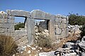
Imperial house wall


literature
- Josef Keil, Adolf Wilhelm: Monuments from the rough Cilicia. (= Monumenta Asiae minoris antiqua Volume 2) Manchester University Press, Manchester 1931.
- Hansgerd Hellenkemper, Friedrich Hild: New research in Kilikien. (= Tabula Imperii Byzantini Volume 4), Verlag der Österreichischen Akademie der Wissenschaften, Vienna 1986, ISBN 3-7001-0771-4 , pp. 56–57.
- Friedrich Hild, Hansgerd Hellenkemper: Kilikien and Isaurien. Tabula Imperii Byzantini Volume 5. Verlag der Österreichischen Akademie der Wissenschaften, Vienna 1990, ISBN 3-7001-1811-2 , p. 376.
Web links
Individual evidence
- ^ German Archaeological Institute: 150 years of the German Archaeological Institute: 1829-1979 . 1981, ISBN 3-8053-0477-3 , pp. 204–209 ( limited preview in Google Book search).