
Turkmenuşağı
| Turkmenuşağı | ||||
|
||||
| Basic data | ||||
|---|---|---|---|---|
| Province (il) : | Mersin | |||
| District ( ilçe ) : | Silifke | |||
| Coordinates : | 36 ° 27 ' N , 34 ° 3' E | |||
| Height : | 387 m | |||
| Residents : | 74 (2019) | |||
| Telephone code : | (+90) 324 | |||
| Postal code : | 33940 | |||
| License plate : | 33 | |||
| Structure and administration (as of 2019) | ||||
| Muhtar : | Harun Kılbıyık | |||


Türkmenuşağı is a hamlet in the Silifke district of the Turkish province of Mersin . Until 2012, Türkmenuşağı was a village with 84 inhabitants at last and then became part of the district center Silifke after a regional reform . The place is about eight kilometers north of the center of Silifke and 60 kilometers southwest of the provincial capital Mersin . It is located near the road that leads from Atakent on the Mediterranean through the mountainous hinterland, past the ancient ruins of Paslı and Tekkadın , via Ovacık and Keşlitürkmenli to Uzuncaburç , the ancient Diokaisareia . In ancient times the place belonged to the Rough Cilicia .
Ancient settlement
In the extensive area of the district lie the ruins of a settlement ( ), which was inhabited in the late Hellenistic , Roman and early Byzantine periods . It was on a low knoll on the road that connected Korasion (Atakent) with the settlement near Gökburç . Remnants of walls from around 30 houses have been preserved, both in small cuboid and in polygonal masonry . You can also see cisterns, there are no traces of a church. To the north of the local area is the Roman temple tomb called Mezgit Kalesi .

House ruin
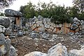
Polygonal masonry
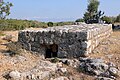
cistern


literature
- Hansgerd Hellenkemper, Friedrich Hild: New research in Kilikien. Publications of the commission for the Tabula Imperii Byzantini Volume 4. Verlag der Österreichischen Akademie der Wissenschaften, Vienna 1986, ISBN 3-7001-0771-4 , p. 451.
- Friedrich Hild , Hansgerd Hellenkemper : Kilikien and Isaurien. Tabula Imperii Byzantini Volume 5. Verlag der Österreichischen Akademie der Wissenschaften, Vienna 1990, ISBN 3-7001-1811-2 , p. 55.
Web links
Individual evidence
- ↑ nufusu.com
- ^ Website Silifke
- ↑ Turkish Institute for Statistics ( Memento from September 21, 2013 in the Internet Archive )