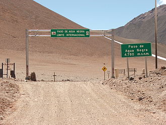
Paso de Agua Negra
| Paso de Agua Negra | |||
|---|---|---|---|
|
Border crossing at Paso del Agua Negra |
|||
| Compass direction | west | east | |
| Pass height | 4780 m | ||
| region | Province of Elqui , Coquimbo , Chile | Iglesia Department , San Juan Province , Argentina | |
| Watershed | Río de la Laguna | Río Agua Negra | |
| Valley locations | Huanta | Las Flores | |
| expansion | unpaved road | ||
| Winter closure | around April to November | ||
| Mountains | To the | ||
| particularities | highest border crossing between Argentina and Chile | ||
| map | |||
|
|
|||
| Coordinates | 30 ° 11 ′ 32 ″ S , 69 ° 49 ′ 6 ″ W | ||
The Paso de Agua Negra (also Paso del Agua Negra , Paso Agua Negra or rarely Paso Aguas Negras ) is a 4780 m (according to other information between 4,753 and 4,779 m) high mountain pass between Chile ( Región de Coquimbo , Ruta CH 41 ) and Argentina ( San Juan Province , RN 150). The pass in the Andes is the highest border crossing between the two states.
The pass connects the town of Huanta in the Elqui Valley on the Chilean side with the Argentinian town of Las Flores . From Huanta the asphalt pass road leads over 24 km to the Chilean border post at Juntas del Toro, from there the road runs as a gravel road along the Río de la Laguna, always gently rising over 83 km to the apex at the border. On the Argentine side, the border post is outside the town of Las Flores, the asphalt pavement ends at the Guardia Vieja police post 35 km away, and after another 40 km the top of the pass is reached.
The pass is only open in the summer months, between December and March; In 2010 the border crossing was closed on May 20 and reopened on November 16 - during the 2009/10 season, 28,907 people crossed the Andes on the Paso de Agua Negra, more than half of them in January. The pass is mostly used by Argentines to spend their holidays on the Chilean coast.
Work on the border pass has been going on since 1947, the road was first opened in 1965 - but the pass remained closed between 1977 and 1994. The construction of two tunnels is currently planned, which should become part of a "bio-oceanic corridor".
Individual evidence
- ^ Wayne Bernhardson: Moon Argentina . Avalon Travel, 2007. ISBN 1566919819 ; P. 252
- ↑ a b La Tercera : Paso internacional de Agua Negra cierra hasta la próxima primavera
- ^ Diario de Cuyo : Paso de Agua Negra: se realizó el corte de cintas
- ↑ sanjuan.gov.ar: 71º Aniversario de Vialidad Provincial ( Memento of November 17, 2011 in the Internet Archive )

