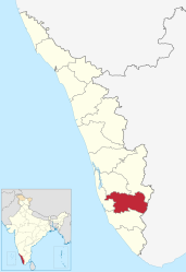
Pathanamthitta (district)
| Pathanamthitta district | |
|---|---|

|
|
| State | Kerala |
| Administrative headquarters : | Pathanamthitta |
| Area : | 2,652 km² |
| Residents : | 1,197,412 (2011) |
| Population density : | 452 inhabitants / km² |
| Website : | pathanamthitta.nic.in |
The Pathanamthitta District ( Malayalam : പത്തനംതിട്ട ജില്ല ) is a district in the southern Indian state of Kerala . The administrative seat is the eponymous city Pathanamthitta . The Pathanamthitta district has an area of 2,652 square kilometers and around 1.2 million inhabitants (2011 census).
geography

The Pathanamthitta district is inland in the southern part of Kerala. Its area is 2,652 square kilometers. The Pathanamthitta district borders on the Kollam districts in the south, Alappuzha in the west, Kottayam and Idukki in the north and Tirunelveli in the east. The latter already belongs to the neighboring state of Tamil Nadu .
The western part of the Pathanamthitta district belongs to the flat coastal hinterland. To the east, the landscape rises over the hilly areas in the center of the district to the mountain range of the Western Ghats , which forms the natural border with Tamil Nadu. More than half of the district area is forested. In the northeast of the Pathanamthitta district is part of the Periyar National Park .
history
During the British colonial period , the area of today's Pathanamthitta district belonged to the princely state of Travancore . After Indian independence, the latter united with Cochin to form the Travancore-Cochin Federation, and in 1949 joined the Indian Union. In 1956 Travancore-Cochin was merged with the Malabar district of the state of Madras to form the new state of Kerala. Pathanamthitta has existed as an independent district since 1982, when it was founded by uniting areas from the districts of Alappuzha, Idukki and Kollam.
population
According to the 2011 Indian census, the Pathanamthitta district has 1,197,412 inhabitants. It is one of the few areas of India with a declining population. Compared to the last census in 2001, the population had declined by 3 percent, while in the same period it increased in the whole of Kerala by 5 percent and in all of India by 18 percent. Compared to the rest of Kerala, the Pathanamthitta district is comparatively sparsely populated. With 452 inhabitants per square kilometer, the population density is well below the Kerala average (860 inhabitants per square kilometer). Only 11 percent of the population live in cities. The degree of urbanization is also significantly lower than the average for the state (48 percent). 14 percent of the district's residents are lower castes ( Scheduled Castes ). At 97 percent, the literacy rate is still higher than the already high average in Kerala (94 percent).
According to the 2011 census , Hindus make up the majority of the residents of the Pathanamthitta district with 57 percent. There is also a large minority of Christians (38 percent) and a smaller minority of Muslims (5 percent). The Pathanamthitta district is one of the most Christian areas of Kerala.
The main language in the Pathanamthitta district, as in all of Kerala, is Malayalam . According to the 2001 census, 99 percent of the district's residents speak it as their first language.
Religious sites
In the Pathanamthitta district there are several important sites of different religious communities. In the densely forested mountains 65 kilometers east of the district capital Pathananamthitta is the Hindu pilgrimage site of Sabarimala . Ayyappan , a regional deity that is particularly popular in Kerala, is worshiped here. Despite its remoteness, Sabarimala attracts several million almost exclusively male pilgrims every year.
Thiruvalla , the largest city in the Pathanamthitta district, is the center of the Mar Thoma Church , a Reformation split of the Thomas Christians . In the small town of Maramon , the Maramon Convention of the Mar-Thoma Church takes place annually, which is the largest Christian event in Asia.
Administrative division
The Pathanamthitta district is divided into five taluks :
| Taluk | main place | Population (2011) |
|---|---|---|
| Adoor | Adoor | 302.936 |
| Kozhenchery | Pathanamthitta | 338,560 |
| Mallappally | Mallappally | 134.219 |
| Ranni | Ranni | 198.194 |
| Thiruvalla | Thiruvalla | 223.503 |
Cities
| city | Population (2011) |
|---|---|
| Adoor | 29,171 |
| Kozhenchery | 12,021 |
| Pathanamthitta | 37,538 |
| Thiruvalla | 52,883 |
Web links
Individual evidence
- ↑ Census of India 2011: Primary Census Abstract - Kerala. (PDF; 522 kB)
- ^ Census of India 2011: Primary Census Data Highlights - Kerala. Chapter - I Population, Size and Decadal Change.
- ^ Census of India 2011: Primary Census Data Highlights - Kerala. Chapter - II Scheduled Castes and Scheduled Tribes Population.
- ^ Census of India 2011: Primary Census Data Highlights - Kerala. Chapter - III Literates and Literacy Rate.
- ^ Census of India 2011: C-1 Population By Religious Community. Kerala.
- ↑ Census of India 2001: C-15: Population by Mother Tongue (Kerala), accessed under Tabulations Plan of Census Year - 2001 .
- ↑ a b Census of India 2011: Primary Census Abstract Data Tables: Pathanamthitta.


