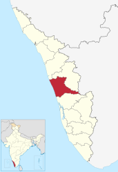
Thrissur (district)
| Thrissur District | |
|---|---|

|
|
| State |
Kerala തൃശ്ശൂർ ജില്ല |
| Administrative headquarters : | Thrissure |
| Area : | 3,032 km² |
| Residents : | 3,110,327 (2011) |
| Population density : | 1,026 inhabitants / km² |
| Website : | thrissur.nic.in |
The Thrissur district ( Malayalam : തൃശ്ശൂർ ജില്ല , formerly Trichur ) is a district in the southern Indian state of Kerala . The administrative seat is the eponymous city of Thrissur .
geography

The Thrissur District is located on the Malabar Coast in central Alcala. It borders the Arabian Sea to the west, the Malappuram district to the north, the Palakkad district to the northeast, the neighboring state of Tamil Nadu ( Coimbatore district ) to the east, the Idukki district to the southeast and the Ernakulam district to the south .
The area of the Thrissur District covers an area of 3,032 square kilometers and extends from the coast in the west to the mountains of the Western Ghats in the east. It is divided into the five taluks Chavakkad, Talappilly, Thrissur, Kodungallur and Mukundapuram.
history
During the British colonial period , most of today's district area belonged to the nominally independent princely state of Cochin . The coastal strip of the district, however, was part of the Malabar district of the Madras Province of British India. After Indian independence, Cochin united with the princely state of Travancore to form the Travancore-Cochin Federation and in 1949 joined the Indian Union. 1956 Thrissur became one of the districts of the newly founded state of Kerala, which had arisen along the language borders of the Malayalam from Travancore-Cochin and the district of Malabar.
population

According to the 2011 census, the Thrissur district has 3,110,327 inhabitants. Between 2001 and 2011, the population grew by 4.6 percent and thus at about the same rate as the average in Kerala (4.9 percent). The population density is 1,026 inhabitants per square kilometer above the already high average of Kerala (859 inhabitants per square kilometer). 67.2 percent of the population of Thrissur district live in cities. The degree of urbanization is thus one of the highest in Kerala and is well above the mean value for the state (47.7 percent). The literacy rate of 95.3 percent corresponds to the average in Kerala (95.2 percent).
In religious terms, the Thrissur district is mixed. According to the 2001 census, a majority of 59.2 percent of the population are Hindu , while there are also large minorities of Christians (24.2 percent) and Muslims (16.4 percent).
Culture and sights
The main attraction of the city Thrissur is the Hindu god Shiva consecrated Vadakkunathan Temple , one of the biggest and oldest Hindu temples of Kerala. Once a year the splendid Thrissur Puram temple festival takes place in Thrissur , with a procession of over 50 festively decorated temple elephants at the center. The festival attracts hundreds of thousands of visitors every year, including many Western tourists.
About 30 kilometers west of Thrissur in the small town of Cheruthuruthy is the Kerala Kalamandalam Art Academy . This institution, founded in 1930, is the most important center for traditional Kerales and Indian performing arts such as Kathakali , Kutiyattam or Bharata Natyam .
Cities
| city | Population (2001) |
|---|---|
| Akathiyoor | 5,273 |
| Avinissery | 11,462 |
| Brahmakulam | 13,026 |
| Chalakudy | 48,371 |
| Chavakkad | 38,138 |
| Chevvoor | 17,373 |
| Guruvayoor | 21,187 |
| Iringaprom | 8,535 |
| Irinjalakuda | 28,873 |
| Kodungallur | 33,543 |
| Kolazhy | 8,445 |
| Koratty | 17,463 |
| Kunnamkulam | 51,585 |
| Marathakkara | 17,934 |
| Methala | 36,317 |
| Nadathara | 12,593 |
| Nenmenikkara | 17.406 |
| Palisserry | 7,950 |
| Paluvai | 7.206 |
| Pavaratty | 10,823 |
| Perakam | 10,356 |
| Pottery | 8,210 |
| Puranattukara | 9,595 |
| Puthukkad | 12,500 |
| Thaikkad | 7,749 |
| Thrissure | 317,474 |
| Vallachira | 13,443 |
| Venmanad | 9,687 |
Web links
Individual evidence
- ^ Census of India 2011: Provisional Population Totals India, Kerala State and Districts. (PDF; 37 kB)
- ↑ Census of India 2011: Provisional Population Totals: India, Kerala State and Districts (PDF; 37 kB) and Rural and Urban Distribution (India, Kerala, Districts) (PDF; 428 kB).
- ^ Census of India 2001: Basic Data Sheet: District Thrissur (07), Kerala (32). (PDF; 55 kB)
- ^ Census of India 2001: Population, population in the age group 0-6 and literates by sex - Cities / Towns (in alphabetic order). ( Memento from June 16, 2004 in the Internet Archive )

