Palakkad (District)
| Palakkad District പാലക്കാട് ജില്ല |
|
|---|---|

|
|
| State | Kerala |
| Administrative headquarters : | Palakkad |
| Area : | 4,480 km² |
| Residents : | 2,810,892 (2011) |
| Population density : | 627 inhabitants / km² |
| Website : | palakkad.gov.in |
The Palakkad District ( Malayalam : പാലക്കാട് ജില്ല , formerly Palghat ) is a district in the southern Indian state of Kerala . The administrative seat is the eponymous city of Palakkad .
geography


The Palakkad district is located in central Alcala on the border with the neighboring state of Tamil Nadu . With 4,480 square kilometers, it is the largest district in Kerala. The district of Palakkad borders on the districts of Thrissur in the southwest and Malappuram in the northwest and in Tamil Nadu on the district of Nilgiris in the north and the district of Coimbatore in the east.
The Palakkad district lies inland at the foot of the Western Ghats , which form the natural border between Kerala and Tamil Nadu. Between Palakkad and the city of Coimbatore in Tamil Nadu, the mountain range of the Western Ghats is interrupted over a distance of around 25 kilometers. This so-called "Palakkad Gap" ( Palghat Gap ) is the only pass between Tamil Nadu and Kerala and therefore represents an important connection between the two states. Most of the district area is flat and is used intensively for agriculture. Therefore, the Palakkad district is known as the "Granary of Kerala". In the north and south, the terrain rises towards the densely forested foothills of the Western Ghats. The Nilgiri Mountains rise to the north and the Anaimalai Mountains to the south . The highest peak in the district is the 2,383 meter high Anginda . The Bharathapuzha River flows from east to west through the Palakkad district.
The Palakkad district is divided into the five taluks Mannarkad, Ottappalam, Palakkad, Alathur and Chittur.
history
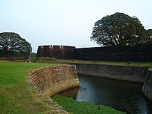
The area of what is now the Palakkad district was originally controlled by local rulers who released their tribute to the Zamorines of Calicut (Kozhikode) at the beginning of the 18th century . When the ruler of Palakkad asked Hyder Ali for support against the Zamorine in 1757 and he built a fortress in Palakkad, the area became involved in the Mysore wars between Mysore and the British . In the course of this, Fort Palakkad changed hands several times before the British finally brought it under their control in 1790. At the end of the Third Mysore War , the area of Palakkad was incorporated as part of the Malabar district into the Madras presidency and thus incorporated into British India . A smaller part of today's district area around the city of Chittur belonged to the princely state of Cochin as an exclave .
After Indian independence, the new state of Kerala was formed in 1956 as part of the States Reorganization Act along the language borders of Malayalam from the Malabar district and the Travancore-Cochin Federation that emerged from the princely states of Cochin and Travancore . At the beginning of 1957, the Palakkad district emerged from the southern parts of the former Malabar district. In 1969 part of the district area was added to the newly founded Malappuram District .
population
According to the 2011 census, the Palakkad district has 2,810,892 inhabitants. Between 2001 and 2011, the population grew by 7.4 percent, a little faster than the average in Kerala (4.9 percent). The population density is 627 people per square kilometer, which is lower than the average of the densely populated state of Kerala (859 people per square kilometer). Only 24.1 percent of the population of Palakkad district live in cities. The degree of urbanization is thus below the average for the state (47.7 percent). At 88.5 percent, the literacy rate is the lowest of all Kerala districts, but is still well above the overall Indian average.
68.9 percent of the inhabitants of the Palakkad Hindus district (2001 census). This means that their share of the population is higher than in other areas of the state, which is very confessionally mixed. There is also a larger number of Muslims (26.9 percent) and a smaller Christian minority (4.2 percent). Due to the close contacts with the neighboring federal state of Tamil Nadu is in the district of Palakkad besides Malayalam , the main language of Kerala, and Tamil spoken.
Cities
| city | Population (2001) |
|---|---|
| Chittur-Thathamangalam | 31,884 |
| Ottappalam | 49,230 |
| Palakkad | 130,736 |
| Puthunagaram | 16,367 |
| Shoranur | 42,022 |
Culture
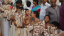
In the Hindu temples consecrated to the goddess Bhadrakali in several villages of the Palakkad district, an annual festival (Puram) lasting up to 21 days is celebrated in spring, to which the shadow play Tholpavakuthu , which is performed as a religious ritual, belongs. This special shadow play tradition, which was previously known in other regions of Kerala, is only maintained in the Palakkad district and in some villages in the area.
Web links
Individual evidence
- ^ Census of India 2011: Provisional Population Totals India, Kerala State and Districts. (PDF; 37 kB)
- ↑ Census of India 2011: Provisional Population Totals: India, Kerala State and Districts (PDF; 37 kB) and Rural and Urban Distribution (India, Kerala, Districts) (PDF; 428 kB).
- ^ Census of India 2001: Basic Data Sheet: District Palakkad (06), Kerala (32). (PDF; 55 kB)
- ^ Census of India 2001: Population, population in the age group 0-6 and literates by sex - Cities / Towns (in alphabetic order). ( Memento from June 16, 2004 in the Internet Archive )


