
Pernio

Perniö [ ˈpɛrniœ ] ( Swedish Bjärnå ) is a former municipality on the coast of southwest Finland . In early 2009 it was incorporated into the city of Salo .
Perniö is located in the Varsinais-Suomi countryside 23 km south of the city center of Salo . It is 75 km to Turku and 132 km to the capital Helsinki . The municipality of Perniö had an area of 408.13 km². The landscape in the former municipal area is characterized by wooded hills and agricultural river valleys. The last population of the municipality was 5,903. Half of the population lived in the parish village of Perniö. Further settlement centers ( taajama ) are Teijo and the train station area (Perniön asemaseutu). The municipality of Perniö was monolingual in Finnish .
The oldest written mention of Perniö comes from 1330. The St. Lawrence Church of Perniö was built around 1480. In the Middle Ages, the location on the Königsstraße , the old route of the Swedish kings from Turku to Viborg , favored the development of manors in Perniö. The culturally and historically valuable ironworks of Mathildedal, Teijo, Koski and Kirjakkala were built in the 17th century . To this day, the metal industry in Perniö is an important branch of business. At the beginning of 2009, Perniö was incorporated into Salo together with the eight communities Halikko , Kiikala , Kisko , Kuusjoki , Muurla , Pertteli , Särkisalo and Suomusjärvi .
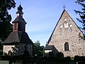
The church of Perniö

The Strömma Canal near Perniö


Individual evidence
- ↑ As of 2008, source: Maanmittauslaitos (Finnish land surveying office) (PDF; 247 kB)
- ↑ As of December 31, 2008. Source: Väestörekisterikeskus (Finnish population register). ( Memento of the original from September 20, 2014 in the Internet Archive ) Info: The archive link was inserted automatically and has not yet been checked. Please check the original and archive link according to the instructions and then remove this notice.
Coordinates: 60 ° 12 ' N , 23 ° 8' E