
Trausnitztalsperre
| Trausnitztalsperre | |||||||
|---|---|---|---|---|---|---|---|
 |
|||||||
|
|||||||
|
|||||||
| Coordinates | 49 ° 31 '9 " N , 12 ° 16' 46" E | ||||||
| Data on the structure | |||||||
| Construction time: | 1951-1952 | ||||||
| Height above valley floor: | 15 m | ||||||
| Height above foundation level : | 20 m | ||||||
| Height of the structure crown: | 402.80 m | ||||||
| Building volume: | 18,500 m³ | ||||||
| Crown length: | 152 m | ||||||
| Crown width: | 5.25 m | ||||||
| Data on the reservoir | |||||||
| Altitude (at congestion destination ) | 401.80 m | ||||||
| Water surface | 37 ha | ||||||
| Storage space | 3 million m³ | ||||||
| Catchment area | 547 km² | ||||||
| Design flood : | 400 m³ / s | ||||||

The Trausnitztalsperre is located on the Pfreimd near Trausnitz in the district of Schwandorf , Bavaria and dams the Pfreimdstausee Trausnitz . It serves as a lower and equalization basin for the Jansen pumped storage plant group and thus for energy generation . It also has its own run-of- river power plant with two Kaplan turbines with a total output of 1.84 MW and an annual electricity production of 3.83 GWh . The mean height of fall is 10.65 m.
description
The barrier structure is a concrete gravity dam that was built from 1951 to 1952 and commissioned in 1952. The air side and the power house are clad with granite masonry. With its three fish-belly weir flaps, the structure looks more like a large weir than a dam .
Picture gallery
Trausnitztalsperre (2013)

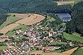
Reservoir near Trausnitz

Power station house


See also
literature
- Peter Franke, Wolfgang Frey: Dams in the Federal Republic of Germany . National Committee for Large Dams in the Federal Republic of Germany - DNK; German Verb. For water management u. Kulturbau eV (DVWK) 1987, ISBN 3-926520-00-0