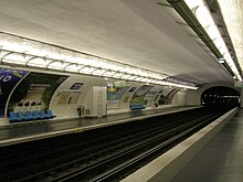
Picpus (Métro Paris)
|
|
|
|---|---|

|
|
| Tariff zone | 1 |
| Line (s) |
|
| place | Paris XII |
| opening | March 1, 1909 |
The metro station Picpus is a station on the line 6 of the Paris Métro .
location
The station is located on the northeastern edge of the Quartier de Picpus in the 12th arrondissement of Paris . It lies lengthways under the Avenue de Saint-Mandé to the west of its intersection with the Boulevard de Picpus.
Surname
It is named after the Boulevard de Picpus, whose name refers to the former hamlet Picpus (or Piquepusse). The origin and meaning of the name have not been clearly clarified. Possibly they go back to an epidemic, the symptoms of which were similar to flea bites (fr: piqûres de puce).
Initially, the station was named "Saint-Mandé" after the street above. In 1937 the name was changed to avoid confusion with the Tourelle station ( opened in 1934 : Saint-Mandé - Tourelle) on Line 1 . The “holy” Mendé was a 7th century Breton hermit whose relics were brought to the Paris region.
The station is nicknamed "Courteline". Georges Courteline (1858–1929), after whom the small green space Square Courteline (in the median of the Boulevard de Picpus and in the middle of its intersection with the Avenue de Saint-Mandé) was named, was a novelist and playwright , member of the Legion of Honor and the Académie Goncourt.
History and description
The station was put into operation on March 1, 1909 by the Compagnie du chemin de fer métropolitain de Paris (CMP) when their route from Nation to Place d'Italie was opened. This was the first and last newly opened section of line 6. In July 1974, line 6 was switched to operation with rubber-tired trains .
The 75 m long station is located under a plastered , white painted elliptical vaulted ceiling. It has 4 m wide side platforms on two main tracks and white tiled side walls that follow the curvature of the ellipse. The only access is on the south side of Avenue de Saint-Mandé west of the above. Crossing, designed by Hector Guimard in the Art nouveau style.
To the east of the station, the route leads in a tight curve of approx. 90 ° under the Boulevard de Picpus. The eastern end loop of line 6 begins not far from the western end of the station .
vehicles
Before 1974, Sprague-Thomson- type trains ran on the route . Since the conversion of line 6 to rubber-tired vehicles, trains of the MP 73 series made up of three multiple units and two sidecars have been running there .
Surroundings
The Cimetière de Picpus cemetery is located near the station . It houses the mass graves of 1306 people who were guillotined during the reign of terror from June 14 to July 27, 1794 on what is now the Place de la Nation .
Remarks
- ↑ The route was completed in 1906, but initially not opened due to the low number of passengers expected
- ↑ Its continuation to Étoile went into operation under line number 2 Sud between 1900 and 1906, but has only been part of line 6 since 1942
- ↑ The side walls of similar stations of the competing company Nord-Sud run in a straight line vertically in the lower area
- ↑ A railcar with a one-sided driver's cab runs at each end of the train, with a driverless cab and two non-motorized sidecars in between
Web links
literature
- Gérard Roland: Stations de métro. D'Abbesses à Wagram . 2003, ISBN 2-86253-307-6 .
Individual evidence
- ^ Gérard Roland: Stations de métro d'Abbesses à Wagram . Christine Bonneton, Clermont-Ferrand 2011, ISBN 978-2-86253-382-7 , pp. 161 .
- ↑ Gérard Roland: op. Cit. P. 194.
- ^ Jean Tricoire: Un siècle de métro en 14 lignes. De Bienvenüe à Météor . La Vie du Rail, Paris 2004, ISBN 2-902808-87-9 , p. 211.
- ^ Brian Hardy: Paris Metro Handbook . 3. Edition. Capital Transport Publishing, Harrow Weald 1999, ISBN 1-85414-212-7 , pp. 36 .
- ↑ Jean Tricoire: op. Cit. P. 43.
| Previous station | Paris metro | Next station |
|---|---|---|
|
Bel-Air ← Charles de Gaulle - Étoile |
|
Nation Nation → |
Coordinates: 48 ° 50 ′ 43 " N , 2 ° 24 ′ 2" E
