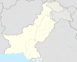
Pind Dadan Khan
| Pind Dadan Khan | ||
| State : |
|
|
| Province : | Punjab | |
| Coordinates : |
32 ° 35 ' N , 73 ° 3' E
|
|
| Residents : | 20,000 | |
| Time zone : |
PST ( UTC + 5 )
|
|
|
|
||
Pind Dadan Khan is a city in Pakistan's Punjab , Jhelam District . It is the capital of the Pind Dadan Khan Tehsil district of the same name , an administrative subdivision of the district mentioned. The city is located on the Jhelam River .
location
The city is located at 32 ° 35'0 "North, 73 ° 3'0" East on the banks of the Jhelam River . The “Pind Dadan Khan” exit of the M2 motorway is approximately 28 kilometers west of the city . The Khewra Salt Mine is six kilometers to the north. The Lillah-Toba interchange of the M2 Highway is 28 kilometers to the east. The city belongs to Union Council number 1. In Pakistan, a “Union Council” or “Sherwan” is an elected administrative body with a “Nazim” at its head, this administration can be formed differently depending on the part of the country and the situation before. The unit to which the city belongs is led by Nazar Hayat Ichhral (Kandwal). The district Jhelam is divided into the four tehsils (circles, sub-units of a district): Jhelum tehsil, Sohawa tehsil, Pind Dadan Khan tehsil and Dina tehsil.
The name of the city is composed of pind and Dadan Khan . In Punjabi , pind means village, locality. Dadan Khan was a humble Sufi from the Awan tribe.
history
During British rule, the city was used as the headquarters of the division and the Tehsil of the same name in the Jhelum District dese British Punjab . In addition, the “Sind-Sagar” branch of the North-Western Railway in British India was moved to the city.
According to the 1901 survey, the city had 13,770 residents. The collection point for the rock salt from the Mayo Mine was located here . From the city it was brought across the river to the railroad and distributed for long-distance trade. However, the bridge over the Jhelam at Haranpur and the extension of the railway line to Khewra mean that the income from this trade monopoly was lost. The city administration was founded in 1867. Most of the income was now collected by the UK authorities and Customs.
This withdrawal of funds made the settlement poor. Before that, the city had extensive and varied production facilities. Brass kettles were made in the city and there was a considerable weaving industry, in particular valuable embroidered textiles. But the skilled workers left the place or changed their occupation. Boat building was carried out on a large scale and the river barges from Pind Dadan Khan enabled a profitable traffic throughout the Jhelam. After the construction of the Mangla Dam , which restricts the amount of water in the river during flooding, this boat industry has also disappeared forever. Once there was a center for the production of unglazed pottery in deep red color and black ornaments of durable and good quality, but this too was abandoned when the artists migrated. Furthermore, a specialty on site was the production of strong leather riding crops based on the English pattern, which were coveted by the British, but this whip production no longer exists after the knowledgeable workers left the city.
Education
During the colonial period there was a university in the city. Today, with the support of the city administration, a college for boys and the colloge for girls, which offer a state degree, have emerged. In addition, a technology college is being established in the state sector. In addition, the “University of Engineering and Technology Texla” has bought a large area of land from the local farmers at nominal price, but the state-run education has not yet started. Only in the private sector did a small campus of the “Punjab Schools and Colleges” begin training. There are many universities in the country that operate in both the public and private sectors. The Raj Baksh Trust high school has produced the best results with extraordinary achievements since it was established by Brigadier General Muhammad Ashraf Retired, a living legend. Mention should be made of the Fauji Foundation's private school and teacher training facility. The city administration also supports the state hospital, but the "Tehsil Headquarters Hospital" is poorly placed in the dispensing of medicines.
population
Around 20,000 people live in the city today, whose main source of income is agriculture. Punjabi is spoken by most families, while Urdu is less common.
Pind Dadan Khan Train Station is a small train station, but it provides a low cost connection for travel.
The time zone of the stat is Pakistan Standard Time (PST).
See also
Individual evidence
- ↑ Tehsils & Unions in the District of Jhelum - Government of Pakistan ( Memento of the original from February 9, 2012 in the Internet Archive ) Info: The archive link was inserted automatically and has not yet been checked. Please check the original and archive link according to the instructions and then remove this notice.
- ↑ Location of Pind Dadan Khan - Falling Rain Genomics
- ↑ a b c d Pind Dādān Khān - Imperial Gazetteer of India, v. 20, page 146


