
Planum Boreum
| Plane on mars | ||
|---|---|---|
| Planum Boreum | ||

|
||
| 3D map calculated from data recorded by Mars Global Surveyor | ||
|
||
| position | 87 ° 19 ′ N , 54 ° 58 ′ E | |
| expansion | 350 km | |

The area around the north pole of Mars , which is girded by Vastitas Borealis , is called Planum Boreum . The counterpart at the South Pole is Planum Australe .
etymology
Planum Boreum - the northern plain - is derived from the Latin adjective planus (even, flat) or from ancient Greek πλάνος and from Boreas , which is borrowed from Βορέας , the Greek god of the north wind Boreas .
description
Planum Boreum lies in a wide depression (unofficially known as the Borealis Basin ) north of 78.5 ° north latitude; it is centered at 88 ° North and 15 ° East. The south adjoining, 1400 km wide band of the vastitas borealis reaches down to 54.7 ° north latitude and dominates the northern hemisphere. Planum Boreum is determined by the dome-like ice layers of the northern ice cap, up to 2 to 3 kilometers thick, which are mainly composed of water ice and some dust (from fine to coarse-grained). During the northern winter, the ice cap is covered by a thin, 1 meter thick layer of dry ice (solid carbon dioxide ). The total volume of the ice cap is 1.12 million cubic kilometers. Its surface is one and a half times the size of Texas and has a diameter of 1200 kilometers. The extent of the ice masses is subject to seasonal fluctuations with a maximum at the beginning of the Martian spring and a minimum in late summer.
Planum Boreum forms an extremely shallow depression. Calculations show that it is in flexural equilibrium with a lithosphere thickness of more than 300 kilometers.
The spiral furrows - spiral cuts in the ice sheet - including the 460 km long, up to 100 km wide and about 2 km deep Chasma Boreale rift ( 82 ° 32 ′ N , 47 ° 38 ′ W ) are striking . The spiral furrows were created by the action of catabatic downward winds in conjunction with ablation or sublimation from solar radiation. The katabatic winds blow the ice out towards the equator and deposit it again on slopes sloping towards the poles. The furrows are arranged almost perpendicular to the wind direction. The Coriolis force deflects the winds blowing south from the North Pole, creating a spiral pattern. Over time, the spiral furrows migrate towards the North Pole - the furrows in the central area have shifted 65 kilometers in the last 2 million years. Chasma Boreale is a much older and much larger canyon that runs parallel to the prevailing wind direction.
The surface composition of the North Pole Cap was investigated from orbit in the Martian spring after the dry ice accumulation in winter. The outer edges of the ice cap, which mainly consists of water ice, are contaminated with up to 0.15% dust . When approaching the pole, the water ice content of the surface decreases and is replaced by dry ice. At the same time, the amount of dust is also reduced. At the pole itself, the surface is essentially pure dry ice with a minimum of 30 ppm water ice.
Striking terrain
The most prominent feature of the Planum Boreum is undoubtedly the Chasma Boreale , a huge trench in the North Pole Cap. The 100 km wide and up to 2 km deep canyon exposed the surface ice and the North Pole layer deposits on its side walls. To the west of Chasma Boreale, the Planum Boreum forms a striking terrain level opposite the lowlands of the Vastitas Borealis, which can usually reach a height of 250 to 300 and in places up to 1000 meters. Further outside, this then dissolves into a collection of mesas and troughs. The tongue of ice separated by Chasma Boreale to the south is known as the Gemina Lingula .
To the south of Planum Boreum is the Olympia Planum , which is filled with huge sand dune fields , the Olympia Undae , between 85 ° and 75 ° north latitude . Other dune fields are Abalos Undae and Hyperboreae Undae . Olympia Undae, the largest of these fields, extends from 100 ° to 240 ° longitude, Abalos Undae is between 261 ° and 280 ° longitude, and Hyperboreae Undae is between 311 ° and 341 ° longitude.
Avalanches

HiRISE was able to observe four avalanches over a 700 meter high steep face. The dust cloud of fine suspension material is 180 meters wide and, measured from the foot of the wall, reaches a distance of 190 meters. The red layers contain water ice, while the white layers consist of winter carbon dioxide frost. The avalanche has obviously come off the top red layer. Follow-up investigations should provide clarity about the nature of the deposits.
Recurring ring cloud

Every Martian year, a ring cloud of constant size appears over the North Pole region at roughly the same time. It forms in the morning and then dissolves again in the afternoon. The outer diameter of the cloud is around 1000 kilometers, the diameter of the inner eye 320 kilometers. Since this ring cloud probably contains water ice, it is white in color, unlike dust storms.
The ring cloud resembles a cyclonic hurricane , but shows no rotational movement. It appears at high latitudes during the northern summer. Their formation is likely to be related to the unique climatic conditions at the North Pole. Cyclones on Mars have already been recorded by the Viking probes, but the annular cloud is three times as large. The toroidal cloud was recorded by various probes, including Hubble in 1999 and Mars Global Surveyor .
Areology
The areological subsoil of the Planum Boreum is formed by layers of the hesperium (unit Hpu ). The shift packages in the decameter area are open in the valley floor of the Chasma Boreale and in the Rupes Tenuis . They are covered by the layer deposits of the Amazon (unit Apu ), which make up the main part of the ice sheet. On top of this lie the Young Amazonian ice layers (unit lApc ), which are no more than 2 meters thick. The Young Amazon sand dune formations such as the Olympia Dunae (unit lApd ) lie outside the ice sheet. You can find soap, barchan and other types of dunes in the decameter range, and permafrost phenomena are not uncommon. They cover either late Hesperian lowland sediments lHl , Hesperian layer deposits Hpu , middle to late Amazonian layer deposits of the Apu ice sheet or rough Hesperian constructs Hpe of the Scandia Cavi and Scandia Tholi .
The Young Amazon Ice Sheet is assigned an age of less than 10 million years.

Small impact crater in the layer deposits of the Planum Boreum

Sublimation of the dry ice layer on sand dunes in spring
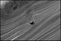
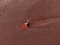
Conical elevation in a furrow at the North Pole

Linear dunes with polygonal surface in Planum Boreum
Filled impact crater in the deposits of Planum Boreum

Defrosted edge of the dune field
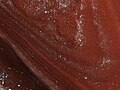
Stratigraphy of the deposits in the Planum Boreum

Northern Hemisphere topography


Web links
- science.orf.at: Wind formed the north pole of Mars
- Natural wonders, Mathias Scholz: Planet Mars (19) - polar caps, October 2011
- Natural wonder, Mathias Scholz: Planet Mars (20) - The North Polar Cap, October 2011
Individual evidence
- ↑ Planum Boreum in the IAU's Gazetteer of Planetary Nomenclature (WGPSN) / USGS
- ^ RJ Phillips et al .: Mars north polar deposits: Stratigraphy, age, and geodynamical response . In: Science . tape 320 , 2008, p. 1182-1185 .
- ↑ Isaac B. Smith, JW Holt: Onset and migration of spiral troughs on Mars revealed by orbital radar . In: Nature . tape 465 , no. 4 , 2010, p. 450–453 , doi : 10.1038 / nature09049 ( nature.com ).
- ↑ G. Granada: Spatial variability and composition of the seasonal north polar cap on Mars . 2006 ( jussieu.fr [PDF]).
- ^ D. Brand, R. Villard: Colossal cyclone swirling near Martian north pole is observed by Cornell-led team on Hubble telescope. ( Memento from August 5, 2012 in the web archive archive.today ) In: Cornell News. 1999.
- ↑ P. Thomas and others: Polar deposits of Mars . In: HH Kieffer et al. (Ed.): Mars . Univ. of Arizona Press, Tucson 1992, pp. 767-795 .