
Plattenkogel
| Plattenkogel | ||
|---|---|---|
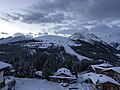
.jpg) View of Königsleiten |
||
| height | 2039 m above sea level A. | |
| location | Salzburg , Austria | |
| Mountains | Zillertal Alps | |
| Coordinates | 47 ° 13 '28 " N , 12 ° 8' 6" E | |
|
||

The Plattenkogel , also called Gerlosplatte , is a much- walked one, 2039 m above sea level. A. high panoramic mountain in the Zillertal Alps in the Austrian state of Salzburg , which is heavily developed for tourism. Its summit was declared a natural monument in 1933 .
Location and development
The mountain is located east of the Durlaßboden reservoir , south of the Gerlos Pass and west of the Salzach Valley . The closest places are Königsleiten and Krimml . A network of hiking trails and numerous ski lifts open up the Plattenkogel, which is part of the Zillertal Arena .
Natural monument
The natural monument summit of the Plattenkogel is one of the oldest protected objects in the state of Salzburg . A circular area with a radius of 150 m is protected. For this reason, the lifts do not lead to the immediate summit area.
The following biotopes are protected on the Plattenkogel or its immediate vicinity: Alpine rose population , Rostseggenrasen, dwarf shrub heather .
gallery

Summit cross in winter

Summit area in winter

View from the Königsleitenspitze
View of Königsleiten

Summit area in summer

View from the Königsleitenspitze

Information board natural monument
.jpg)

.jpg)
2.jpg)

.jpg)

See also
Web links
- Hiking circuit on outdooractive.com - accessed on January 21, 2017
- WebCam at zillertalarena.com - accessed on September 14, 2019
- Map at peakhunter.com - accessed January 21, 2017
Individual evidence
- ↑ Protected area: summit of the Plattenkogel. State of Salzburg, accessed on January 21, 2017 .