Starzlen
| Starzlen | ||
|
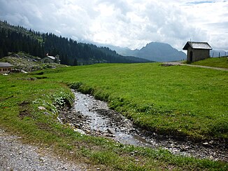
Upper course of the Starzlen at the Pragel Pass |
||
| Data | ||
| Water code | CH : 4334 | |
| location | Canton of Schwyz ; Switzerland | |
| River system | Rhine | |
| Drain over | Muota → Reuss → Aare → Rhine → North Sea | |
| Headwaters | below the Mieserenstock 47 ° 0 ′ 7 ″ N , 8 ° 51 ′ 42 ″ E |
|
| Source height | approx. 1755 m above sea level M. | |
| muzzle | near the village of Muotathal in the Muota coordinates: 46 ° 58 ′ 24 " N , 8 ° 46 ′ 41" E ; CH1903: 701 924 / 203353 46 ° 58 '24 " N , 8 ° 46' 41" O |
|
| Mouth height | 630 m above sea level M. | |
| Height difference | approx. 1125 m | |
| Bottom slope | approx. 12% | |
| length | 9.5 km | |
| Catchment area | 26.05 km² | |
| Discharge at the A Eo estuary gauge : 26.05 km²
|
MQ Mq |
1.64 m³ / s 63 l / (s km²) |
| Right tributaries | Gämsstafelbach, Rotenbach, Teufbach | |
| Communities | Muotathal | |
The Starzlen is an approximately ten kilometer long right tributary of the Muota in the Swiss canton of Schwyz .
course
The Starzlen rises a little below the Mieserenstock at about 1755 m above sea level. M. above the Pragelpass right next to the source area of the Chlü . It flows first through the fens Pragel and Guetentalboden , both in the federal inventory of fens of national importance are registered. After the confluence of the Gämsstafelbach from the right, it crosses the densely wooded Starzlen Gorge , which only opens again at Stalden .
At Stalden it takes on the Rotenbach and the Teufbach in quick succession from the right , before reaching 630 m above sea level. M. at the village of Muotathal flows from the right into the upper reaches of the Muota.
Catchment area
The catchment area of the Starzlen extends over an area of 26.05 square kilometers. It consists of 36.6% agricultural area, 31.8% wooded area, 29.6% unproductive area, 1.2% water area and 0.8% settlement area. The highest point is at 2316 m above sea level. M. a little below the Silberens , the average altitude is 1502 m above sea level. M.
In the north is the catchment area of the Sihl and its tributary Minster with its tributary Minster , in the east that of the Chlü , which drains into the Linth .
Individual evidence
- ↑ a b c d Geoserver of the Swiss Federal Administration ( information )
- ↑ a b Modeled mean annual discharge. In: Topographical catchment areas of Swiss waters: sub-catchment areas 2 km². Retrieved November 27, 2016 .
