Flat Habach
| Flat Habach | ||
|---|---|---|
|
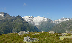
View from St. Pöltner Ostweg (Grünsee) to the Großvenediger (center of the picture, glacier summit). On the right is the flat Habach. |
||
| height | 3207 m above sea level A. | |
| location | Tyrol and Salzburg , Austria | |
| Mountains | Venediger group | |
| Dominance | 0.5 km → Hohe Fürleg | |
| Notch height | 42 m ↓ Habachkeessschneide | |
| Coordinates | 47 ° 8 '28 " N , 12 ° 22' 16" E | |
|
|
||
| First ascent | around 1868 by Paul Grohmann and a shepherd | |
| Normal way | From the Habachscharte | |
The Plattiger Habach is 3207 m above sea level. A. high mountain peaks in the Tauern main ridge in the Venediger group on the border between East Tyrol and Salzburg . The Plattige Habach is hidden, is hardly independent and little known and is therefore rarely committed. It was first climbed around 1868 by Paul Grohmann and a shepherd.
location
The Plattige Habach is on the border of the municipality of Matrei in Osttirol in Osttirol and the state of Salzburg. Neighboring mountains are the Hohe Fürleg ( 3243 m ) in the west and the Schwarzkopf ( 2996 m ) in the east. The Plattige Habach is separated from the Schwarzkopf by the Habachscharte. The Plattige Habach itself rises above the Habachkess in the north and the Northern Villhabenkess in the south.
Promotion opportunities
The normal ascent usually starts from the Venedigerhaus in Innergschlöß and leads over a steep path into the Villtragental. Then you climb up to the right to the northern Villträgerkees marked to below the Schwarzkogelscharte. Then the ascent takes place over the Kees in a loop to the left below the Green Habach into the Habachscharte. Then you can climb the Plattigen Habach along the ridge or to the right of the summit on the glacier. When climbing this route, 1500 meters of altitude and a distance of 8 kilometers in one direction have to be overcome. The Hohe Fürleg can be reached almost flat from the Plattigen Habach.
Individual evidence
- ^ Federal Office for Metrology and Surveying Austria: Austrian Map online (Austrian map 1: 50,000) .
- ↑ Willi End; Hubert Peterka: Venediger Group. Munich 1994, p. 301
literature
- Georg Zlöbl: The three thousand meter peaks of East Tyrol in the Hohe Tauern National Park. Verlag Grafik Zloebl, Lienz-Tristach 2007, ISBN 3-200-00428-2 .

