Pleasant Valley Township (Scott County, Iowa)
| Pleasant Valley Township | ||
|---|---|---|
|
Location in Iowa
|
||
| Basic data | ||
| State : | United States | |
| State : | Iowa | |
| County : | Scott County | |
| Coordinates : | 41 ° 34 ′ N , 90 ° 28 ′ W | |
| Time zone : | Central ( UTC − 6 / −5 ) | |
| Residents : | 34,936 (as of 2010) | |
| Population density : | 514.5 inhabitants per km 2 | |
| Area : | 72.9 km 2 (approx. 28 mi 2 ) of which 67.9 km 2 (approx. 26 mi 2 ) is land |
|
| Height : | 192 m | |
| Postal code : | 52722 | |
| Area code : | +1 563 | |
| FIPS : | 19-93420 | |
| GNIS ID : | 468548 | |
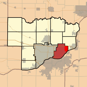
 Location of the Pleasant Valley Township in Scott County |
||
The Pleasant Valley Township is one of 13 townships in Scott County in eastern US -amerikanischen State of Iowa and part of the metropolitan Quad Cities .
geography
The Pleasant Valley Township is located on the Mississippi , which forms the border between Iowa and Illinois . The township extends over 72.9 km², which is spread over 67.9 km² of land and 5.0 km² of water. Neighboring in Scott County are Le Claire Township in the northeast and Lincoln Township in the north, and the non-township town of Davenport in the west. To the south and southeast, the Pleasant Valley Township borders the Mississippi, which forms the border with Rock Island County in Illinois.
population
At the 2010 census , the township had 34,936 residents.
Places in the Pleasant Valley Township
There are three independent communities in Pleasant Valley Township, all of which have City status:
Individual evidence
- ↑ Missouri Census Data Center - Iowa ( page no longer available , search in web archives ) Info: The link was automatically marked as defective. Please check the link according to the instructions and then remove this notice. Retrieved March 16, 2012
