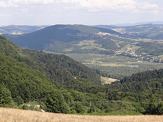
Central Beskid promontory
| Central Beskid promontory | ||
|---|---|---|
| Highest peak | Suchy Obycz ( 616 m npm ) | |
| location | Poland | |
| part of | Western Carpathians | |
|
|
||
| Coordinates | 49 ° 36 ' N , 22 ° 39' E | |
The Central Beskid Foothills ( Pogórze Środkowobeskidzkie in Polish ) is a mountain range of the Western Carpathians in Poland ( Lesser Poland Voivodeship and Subcarpathian Voivodeship ). Its highest peak is the Suchy Obycz with 616 m in the Przemyśl Mountains .
Demarcation
In the north the Northern Carpathian Mountains and in the south the West and Central Beskids join. They belong to the Outer Western Carpathians .
structure
The Mittelbeskiden foothills are divided into seven mountain ranges, a depression and a basin:
- Pogórze Rożnowskie ( Rożnów Mountains )
- Pogórze Ciężkowickie ( Ciężków Mountains )
- Pogórze Strzyżowskie ( Strzyżów Mountains )
- Pogórze Dynowskie ( Dynów Mountains )
- Pogórze Przemyskie ( Przemyśl Mountains )
- Obniżenie Gorlickie ( Gorlice Depression )
- Kotlina Jasielsko-Krośnieńska ( Jasło-Krosno Basin )
- Pogórze Jasielskie ( Jasło Mountains )
- Pogórze Bukowskie ( Buków Mountains )
proof
- Jerzy Kondracki: Geografia regionalna Polski. Warszawa: Wyd. Naukowe PWN, 1998. ISBN 83-01-12479-2 .
Left
- Commons : Pogórze Środkowobeskidzkie - collection of pictures, videos and audio files


