
Pohanské Kameny
| Pohanské Kameny | ||
|---|---|---|
 |
||
| height | 297 m | |
| location | Czech Republic | |
| Mountains | Jizera foothills | |
| Coordinates | 50 ° 58 '24 " N , 15 ° 1' 16" E | |
|
||
| particularities | Granite rock group | |

The Pohanské Kameny (German Hain , also Windmühlenberg , Götterhain , Hähnel , Michelsberg ) are a hill in the Czech Republic . The partly wooded elevation with a height of 297 m above sea level is just under a kilometer north of Višňová on the Polish- Czech border. In the notch to the southern secondary summit (288 m above sea level) is the legendary Heidenstein ( Pohanské Kameny ) rock formation , also known as the Great Stone .
geography
The hill rises on the left side above the valley of the Smědá ( Wittig ), to the south lies the valley of the Višňovský potok ( Weigsdorfer Bach ). The Višňová station is located at its eastern foot on the Liberec – Zawidów railway line . To the east rises the Hradec ( Abtsberg , 313 m), in the northwest of the Větrný ( Lohnberg , 385 m).
Surrounding towns are Filipovka in the north, Michalovice in the northeast, Předlánce in the east, Višňová in the south, Wyszków in the southwest and Wolanów and Saň in the northwest.
Heidenstein
The group, surrounded by a deciduous forest, consists of six mighty boulders made of Rumburg granite ( 50 ° 58 ′ N , 15 ° 1 ′ E ), five of which stand together, with one, the sacrificial table, lying on top of two others and forming an open rock gate. The sixth block is separated from the main rock by a passage for two people. Originally there was still a seventh boulder on the main structure, but at some point it fell and shattered.
The rock formation was regarded as a dolmen until the 19th century and popularly referred to as Druisteine , idol temple or sacrificial table .
Around 1830, the oak and birch groves surrounding the rocks were cleared and converted into arable land, thereby exposing the rock and later making it accessible as a viewing point via a staircase. From the Hain and Heidenstein there was a wide view over the Wittig valley to the Jizera Mountains and to the west into the Zittau basin through which the Küpper and Neisse River flows .
There are several legends about the Heidenstein, including the one about the devil's coach and about the buried gold treasure.
history
Archaeological finds prove the presence of humans on the Heidenstein since the Neolithic Age , making it one of the oldest settlements in the Jizera Mountains foothills alongside the Chlum ( High Grove ) near Raspenava . It is believed that the rock was a pre-Christian cult site.
According to tradition, there was a sacred grove ( sacrificial hayn ) on the hill , after which Haynstrasse, the Haynbrunnen and the Hayn estate were named. At the beginning of the 17th century, older residents of Weigsdorf went to prayer on the Heidenstein at sunrise and sunset. In 1614, the Weigsdorf pastor Martin Nigert Tropanus noticed an old woman praying on the Heidenstein. She explained to him that she and her grandmother had already gone to prayer in the morning and evening on the mountain, where there was a temple of God, and that there she could look closer into the face of God than in the old, dark church.
Until 1635, Hayn belonged to the Kingdom of Bohemia as part of Upper Lusatia and was then located in the Electorate of Saxony close to the Bohemian border. In the course of the border recession of 1848, the Hayn became Bohemian again when the border around Weigsdorf was cleared and belonged to the cadastre of Böhmisch Weigsdorf
Preusker described the sacrificial rock in 1841 as an old Germanic sun temple and saw a connection to the Venusstein on the Wittig near Neu-Dörfel as well as the rock (devil's chair and devil's bowl) near Maxdorf ( Wyszków ), which, however, were completely demolished by a quarry around 1820, as all three Rock formations to one another formed roughly the shape of an equilateral triangle.
Ernst Willkomm wrote in 1844: "The sacrificial stones near Weigsdorf are strikingly reminiscent of the English Stonehenge ..."
In earlier times, unglazed remains of vessels with figures as well as ground or pierced stones were found as the remains of stone axes. In times of war, the inhabitants of the places hid their cattle and belongings in the caves between the rocks.
For the solstice celebration, the rock was a meeting place for the youth of the surrounding Upper Lusatian and Bohemian villages, who met there for the Midsummer bonfire. He was also visited by young people on Easter Day and at Latars. When a Weigsdorf landowner wanted to use the rocks as a quarry, the people of Weigsdorf resisted.
Preusker saw the seven kettle-like holes arranged in a semicircle around a depression on the offering table and another round depression on an adjacent block ( devil's chairs or devil's seats ) as man-made. He suspected a natural origin in two further semicircles in the northern part of the Heidenstein, resembling seats. Overall, he saw in it signs of an earlier use of the Heidenstein as a pre-Christian place of worship.
In 1895 the Berlin archaeologist Rudolf Virchow examined the rock pots on the sacrificial table as part of an anthropological study of the Lusatian culture and came to the conclusion that these were depressions caused by the weather.
Archaeological investigations carried out on the Heidenstein in the first half of the 20th century uncovered the remains of stone axes and other objects from the Neolithic Age .
After the end of the Second World War, the fields around the Heidenstein remained uncultivated, so that a little wood formed around the rock, which today prevents any view. The unforested main summit, however, offers a wide view.
On the north side of the Heidenstein there is a marble plaque on the iron staircase, which reminds of the investigation by Rudolf Virchow.

Heidenstein with ascent and a historical memorial plaque from 1895
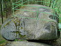
Summit stone of the Heidenstein with weather basins, the so-called devil's or priest's seats

The sacrificial or large stone near Weigsdorf, drawing by Karl Benjamin Preusker in 1844


Solar phenomenon
Since 2008, the archaeoastronomy group of the public and school observatory "Bruno-H.-Bürgel" in Sohland / Spree has been examining various rocks in Upper Lusatia and neighboring regions for their suitability for calendar solar observations. The archaeoastronomical research project was given the name “Project Gods Hand ” and the rock objects that show the calendar solar observation phenomenon are referred to as the “ Sun Sanctuaries of Upper Lusatia ”. On April 17, 2011, the Pohanské Kameny rock gate was also measured and found to be suitable for observing the sunset at the summer solstice and the sunrise at the winter solstice . At the summer solstice of 2014, the first photos of the passage of the sun in the rock gate were taken on the initiative of astronomical enthusiasts from Kunratice u Frýdlantu .
literature
- Karl Preusker : Glimpses into the patriotic prehistoric times , first volume, Leipzig 1841, § 2 - Sacrificial rocks near Weigsdorf, not far from Zittau
- Ralf Herold, The Track of Light - Project of the Gods - Sun Sanctuaries of Upper Lusatia. Sohland / Spree observatory, Books on Demand, Norderstedt 2020, ISBN 978-3-7519-5892-9
Web links
Individual evidence
- ↑ Concise dictionary of German superstitions , Vol. 8 Silber-Vulkan, De Gruyter 1936, p. 71
- ↑ Ernst Willkomm, "Silhouette from the life of the people and princes", 1844, p. 72
- ↑ Infopack 2011, "Sun Sanctuaries of Upper Lusatia", observatory "Bruno-H.-Bürgel" Sohland / Spree; Ralf Herold: Sun Shrines of Upper Lusatia - The money cellar on the Löbauer Berg and its real treasure. Oberlausitzer Verlag, 2012
- ↑ International Day of Archaeoastronomy 2014 at the Sohland Observatory (Pohanské Kameny in the video from min. 15:23)