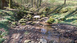
Bach of Götterhain
|
Bach von Götterhain Bach vom Götterhain |
||
|
The brook of Götterhain in the rock gorge |
||
| Data | ||
| Water code | DE : 2474534 | |
| location |
Hessian-Franconian mountainous region
|
|
| River system | Rhine | |
| Drain over | Mümling → Main → Rhine → North Sea | |
| source | northeast of Rehbach 49 ° 42 ′ 40 ″ N , 8 ° 58 ′ 5 ″ E |
|
| Source height | 300 m above sea level NHN | |
| muzzle | near Zell im Odenwald in the Mümling coordinates: 49 ° 43 '9 " N , 8 ° 59' 28" E 49 ° 43 '9 " N , 8 ° 59' 28" E |
|
| Mouth height | 185 m above sea level NHN | |
| Height difference | 115 m | |
| Bottom slope | 55 ‰ | |
| length | 2.1 km | |
| Catchment area | 2 km² | |
The stream of Götterhain is a good two kilometers long, southwest and left tributary of the Mümling near Bad König in the Hessian Odenwaldkreis .
geography
course
The stream of Götterhain rises at an altitude of 300 m above sea level. NHN northeast of Rehbach am Keltenhain (formerly called Götterhain ), near the ESOC ground station Michelstadt .
It flows northeast and reaches a narrow rock canyon. There it crosses under the federal highway 45 and finally flows out at an altitude of about 185 m above sea level. NHN near Zell im Odenwald from the left into the Mümling .
The approximately 2.1 km long course of the Götterhain brook ends about 115 meters below its source, so it has a mean bed gradient of 55 ‰.
Catchment area
The catchment area of about 2 km² of the Götterhain brook lies in the sandstone forest and is drained through it via the Mümling, the Main and the Rhine to the North Sea.
It borders
- in the north to that of the Brombach , which flows into the Mümling
- and in the south to that of the Rehbach , also a tributary of the Mümling.
The catchment area is dominated by arable land on the upper reaches and grassland predominates in the lower reaches. The mountain slopes in the north are partly forested.

