Pola (Ilmensee)
|
Pola Пола́ |
||
| Data | ||
| Water code | RU : 01040200312102000021830 | |
| location | Tver , Novgorod Oblast ( Russia ) | |
| River system | Neva | |
| Drain over | Volkhov → Neva → Baltic Sea | |
| source | Northwest flank of the Waldai heights 57 ° 0 ′ 19 ″ N , 31 ° 58 ′ 49 ″ E |
|
| muzzle | in the Ilmensee coordinates: 58 ° 12 '35 " N , 31 ° 38' 5" E 58 ° 12 '35 " N , 31 ° 38' 5" E |
|
| Mouth height |
18 m
|
|
| length | 267 km | |
| Catchment area | 7420 km² | |
| Drain |
MQ |
63 m³ / s |
| Right tributaries | Schtscheberecha , Jawon , Polomet River | |
|
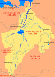
Course of the Pola (Пола) in the catchment area of the Volkhov |
||
The Pola ( Russian Пола́ ) is a tributary of Lake Ilmen in the Russian oblasts of Tver and Novgorod .
The Pola rises on the northwest flank of the Valdai heights in the Tver Oblast. It flows in a predominantly northerly direction through the south of Novgorod Oblast to Lake Ilmen, in whose southeastern bank it flows. In the lower reaches - not far from the mouth - the rivers Pola and Lowat meet . The two rivers are connected to each other over a distance of about 100 m. Larger tributaries are Schtscheberecha , Jawon and Polomet River (all right).
The Pola has a length of 267 km. It drains an area of 7420 km². It is mainly fed by the snowmelt . In spring the river is flooded . In summer and autumn, however, the river has low water. The mean discharge of the Pola is 63 m³ / s. The river freezes in November / December. In March / April the water surface thaws again.
The river has been used for rafting , at least in the past .

