Pont Marie
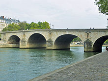
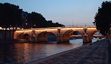
The Pont Marie is a stone arch bridge over the Seine in the 4th arrondissement of Paris and the second oldest surviving bridge in the city after the Pont Neuf .
History of origin
The forerunner of the Pont Marie was a wooden bridge called Pont de Fust and was destroyed by a period of frost in January 1408. For more than 200 years this place remained without a bridge. The Pont Marie was built by the builder Christophe Marie between 1614 and 1635 and named after its builder. Christophe Marie was also responsible for monitoring all Parisian bridges. The building application was submitted in 1605, but there were numerous reasons for the delay in planning permission. Marie was initially able to acquire the area required to build the bridge for one denier per square foot . It was not until 1611 that L. Pulletier and F. le Regrattier took care of the financing of the building materials. In addition, the owner of the island, the cathedral chapter of the Notre-Dame de Paris cathedral , was brought in too late. It was finally agreed to pay the church an annual rent of 1200 livres between 1616 and 1618 . The first building plan to take these results into account was submitted on April 19, 1614. The bridge was planned with a span of 47 toises (91.65 m) and a width of 8 toises (15.60 m). Charles Contesse and Jean de la Noue were responsible for the bridge construction.

By King Ludwig XIII. the building permit was granted on May 6, 1614. The first stone was laid by himself on December 11, 1614. The construction work did not get underway until 1623, when Jean de la Grange secured the financing until 1627 and the master mason Rémy Collin took over the construction management. The bridge was given heavy piles so that 50 houses could be built on it. Both sides of the bridge were given 25 houses each, building bridges with houses was common at the time. The foundation stone ceremony took place on October 11, 1624 in the presence of the royal family. Although the bridge was completed in 1630, it was not opened to traffic until 1635. When Marie withdrew from the bridge project in 1643, the master carpenter Claude Dublet was given responsibility for the bridge on June 10, 1643. He had a total of 46 bridge houses built with an area of 30 m² each, which were occupied from 1652 onwards.
A flood on March 1, 1658 swept away 20 of the houses and two arches of the bridge. 60 people were killed. As a replacement, a toll wooden bridge was built at the same place in 1660, which was replaced by a stone structure completed in 1677. In 1769 it was decided not to build houses on the bridge, in 1788 houses on bridges were generally banned in Paris. The bridge originally had 6 arches, one of which was later built into the bank reinforcement. Since February 10, 1887, the bridge has been listed as a Monument Historique . There is a painting of the bridge from 1899 by Maximilien Luce , a French late impressionist painter, on display in the Neue Pinakothek in Munich.
Location and importance
The bridge is 92 m long, 22.60 m wide, of which 14.60 m is road and 4 m each sidewalk. Its stone arches span between 14 m and 18 m. It connects the Seine island Île Saint-Louis with the right bank of the Seine, where the Rue des Nonnains d'Hyères forms its extension. The Pont Marie is the counterpart to the Pont de la Tournelle , which leads to the left bank of the Seine. Both bridges are connected on the island by the Rue des Deux-Ponts (street of the two bridges) . Pont Marie is the middle of the three bridges leading to the Rive Droite . The Métro station Pont Marie on Métrolinie 7 is close by on the right bank of the Seine. Pont Marie is one of the 37 bridges on the Seine in the Paris area .
Individual evidence
- ^ The History of Paris, Volume 3, 1825, p. 136
- ↑ Miron Mislin, The Planning and Building Process of Two Paris Bridges in the Sixteenth and Seventeenth Century , undated, p. 2234 (PDF; 3.1 MB)
- ^ Claude Malingre, Annales de la Ville de Paris , 1640, p. 514
- ^ Andrew Ayers, The Architecture of Paris , 2004, p. 390
- ^ Charles S. Whitney, Bridges of The World: Their Design and Construction , 2003, pp. 141 f.
Coordinates: 48 ° 51 ′ 10.1 ″ N , 2 ° 21 ′ 26.8 ″ E

