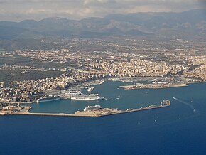
Port de Palma
| Port de Palma | |||
|---|---|---|---|
| Data | |||
| Port type | Ferry port | ||
| Geographic information | |||
| place | Palma | ||
| Autonomous community | Balearic Islands | ||
| Country | Spain | ||
| Port of Palma | |||
| Coordinates | 39 ° 33 '13 " N , 2 ° 37' 45" E | ||
|
|||
Port de Palma ( Castilian Puerto de Palma de Mallorca ) is the port of Palma , the capital of the Spanish island of Mallorca and the autonomous community of the Balearic Islands . The ferry companies Baleària and Trasmediterránea operate from here .
Location and description
The port is located on the west side of the Badia de Palma (“Bay of Palma”) in the southwest of Mallorca. To the south it is shielded from the open sea of the Mediterranean by the Dic del Oest ("Westdeich") . In the north-east this function is taken over by the “old pier”, behind which the yacht club , the Real Club Náutico de Palma , is located in the north of the port facilities . It is joined to the southwest by a pier for excursion boats and the marina .
South below the marina is the Moll de Paraires ("wool workers' mole ") with the ferry terminal . From here the liners operate to the Spanish mainland and the neighboring islands. The adjoining Moll de Ponent ("West Mole") serves as a landing stage for cruise ships. It was extended by 380 meters until summer 2012, which enables five cruise ships to moor at the same time instead of three more than 300 meters long.
In the southwest of the Port de Palma is the small bay of Cala de Porto Pí . The entrance is marked on both sides by two towers, the lighthouse Torre de Porto Pi and the older Torre de Pareires , whose foundations date from Roman times. Today's military port was built in the formerly natural harbor basin of the bay. The Dic del Oest begins at the headland on the south-eastern side of Cala de Porto Pí and extends several hundred meters into the sea, where there are other moorings for cruise ships.
history
The first port facilities below the old town and near Porto Pí are already known from the time of the Moorish rule over Mallorca . Until the beginning of the 19th century, hardly any changes were made to the port of Palma. Since then, it has been continuously expanded to meet requirements.
Up until the middle of the 20th century, most of the shipping and goods traffic was handled at the old pier below the Sa Seu cathedral . Large passenger ships could not moor there. In the 1950s, plans to expand the port were drawn up under the direction of engineer Gabriel Roca . The expansion included the Dic del Oest , the Moll de Paraires and the Moll de Ponent . The official inauguration of the West Harbor took place on July 24, 1961.
Ferry connections
- Palma - Barcelona
- Palma - Dénia (via Eivissa)
- Palma - Formentera
- Palma - Eivissa (Ibiza)
- Palma - Maó (Mahon)
- Palma - Valencia
Individual evidence
- ↑ a b Palma's gateway to the world . In: Mallorca Magazin . No. 37/2011 . Grup Serra / Grupo Serra, Palma September 15, 2011, p. 47/48 ( mallorcamagazin.com ).
- ↑ Història de Port de Palma. Authority Portuària de Balears. www.portsdebalears.com, archived from the original on September 5, 2011 ; Retrieved November 23, 2011 (Catalan).
Web links
- Marina Port de Mallorca. portdemallorca.com (Castilian, English, German)
- Port de Palma. ( Memento of May 17, 2008 in the Internet Archive ) Ports de Balears, www.portsdebalears.com (Castilian)

