Porte Dauphine (Paris Métro)
|
|
|
|---|---|

|
|
| Tariff zone | 1 |
| Line (s) |
|
| place | Paris XVI |
| opening | December 13, 1900 |
| Connected stations |
Avenue Foch → |

Porte Dauphine is the western terminus of line 2 of the Paris Métro . At the nearby Avenue Foch train station , you can change to the RER C line of the S-Bahn- like Réseau Express Régional .
location
The metro station is located in the Quartier de la Porte-Dauphine in the 16th arrondissement of Paris . It is below Avenue Foch at its western end.
Surname
It is named after the Porte Dauphine , a former gate at the end of the “Belle Faisanderie” pheasant garden by Marie Antoinette . Through her marriage to the French heir to the throne and later King Louis XVI. In 1770 she became a Dauphine (wife of the heir to the throne).
The station bears the suffix "Maréchal de Lattre de Tassigny". As commander of the 1st French Army, Jean de Lattre de Tassigny liberated southeastern France during World War II and then conquered parts of southwestern Germany . The honorary title Marshal of France was awarded to him posthumously in 1952 .
History and description
The metro station went into operation on December 13, 1900, when the first section of Line 2 from Porte Dauphine to Étoile (since 1970: Charles de Gaulle - Étoile ) was opened.
It consists of two 75 m long, separate stations that are located on the legs of an end loop . The arrival station has a side platform to the north of the track, which branches off the track axis shortly before at about 20 °. Next to the main track there is a siding that leads into the departure track and ends bluntly at the western head of the station .
A single-track curve with a radius of only 30 m, over which the trains sweep, leads to the departure station, which is in the line axis. It is driven through in a counter-clockwise direction. The station has a central platform, the northern track of which is also a stump track. The main tracks then meet again in the shared tunnel, where a simple change of track enables arriving trains to approach the departure platform directly.
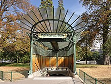
For the stations, a vault was built by miners just below the road surface. For both stations, which still have the original tiles from 1900, there is only one common access. The access structure designed by Hector Guimard is the penultimate one of its kind and the only one that still stands in its original location.
vehicles
Until October 1902 two-axle railcars with wooden superstructures ran on the route. Unlike those on Line 1, they had two driver's cabs, as they had to be moved to the other end of the train at the provisional Ètoile coupling point . Initially, two sidecars were carried. After the line was extended to Anvers on October 7, 1902, trains were made up of six sidecars and one railcar at each end of the train.
From 1914 to 1981 line 2 was used by five-part, green-painted trains of the Sprague-Thomson design . Since it was not to be converted to vehicles with rubber tires in the medium term, the MF 67 series was launched in 1979 , completely replacing its predecessor within two years. Series vehicles of the MF 01 series have been in use since 2008, and exclusively since 2011.
Remarks
- ↑ To distinguish it from line 2 south (part of today's line 6), the line was initially called 2 north
- ↑ The underground station is the last one that still has tiles of the “large and flat” type
- ↑ Towards the end of their service life, gray Sprague Thomson trains, which were originally reserved for Line 1, were also put on Line 2
Web links
- Plan of the tracks and platforms at carto.metro.free.fr
literature
- Gérard Roland: Stations de métro. D'Abbesses à Wagram . 2003, ISBN 2-86253-307-6 .
Individual evidence
- ^ A b Gérard Roland: Stations de métro d'Abbesses à Wagram . Christine Bonneton, Clermont-Ferrand 2011, ISBN 978-2-86253-382-7 , pp. 170 .
- ↑ a b Jean Tricoire: Un siècle de métro en 14 lignes. De Bienvenüe à Météor . 2nd Edition. La Vie du Rail, Paris 2000, ISBN 2-902808-87-9 , p. 146 .
- ^ Brian Hardy: Paris Metro Handbook . 3. Edition. Capital Transport Publishing, Harrow Weald 1999, ISBN 1-85414-212-7 , pp. 36 .
- ^ Brian Hardy: op. Cit. P. 8.
- ↑ Jean Tricoire: op. Cit. P. 160.
- ^ Brian Hardy: op. Cit. P. 34.
- ↑ Jean Tricoire: op. Cit. P. 154.
- ^ Julian Pepinster: Le métro de Paris . Éditions La Vie du Rail, Paris 2010, ISBN 978-2-918758-12-9 , p. 185 .
| Previous station | Paris metro | Next station |
|---|---|---|
| final destination |
|
Victor Hugo Nation → |
Coordinates: 48 ° 52 ′ 17.7 " N , 2 ° 16 ′ 30.6" E


