Pottstown
| Pottstown | ||
|---|---|---|
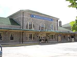
 Former Pottstown Railway Station, now the Harleysville National Bank. |
||
| Location in Pennsylvania | ||
|
|
||
| Basic data | ||
| Foundation : | 1761 | |
| State : | United States | |
| State : | Pennsylvania | |
| County : | Montgomery County | |
| Coordinates : | 40 ° 15 ′ N , 75 ° 38 ′ W | |
| Time zone : | Eastern ( UTC − 5 / −4 ) | |
| Residents : | 22,377 (as of 2010) | |
| Population density : | 1,864.8 inhabitants per km 2 | |
| Area : | 13.0 km 2 (approx. 5 mi 2 ) of which 12.0 km 2 (approx. 5 mi 2 ) are land |
|
| Height : | 61.9 m | |
| Postal code : | 19464 | |
| Area code : | +1 610 | |
| FIPS : | 4262416 | |
| GNIS ID : | 1214003 | |
| Mayor : | Sharon Thomas | |
 |
||
Pottstown is a borough in Montgomery County in the southeast of the US state Pennsylvania with just under 22,377 inhabitants.
The place, a good 55 km northwest of Philadelphia , was founded in 1761 by John Potts on his own land.
Population development
| 1900 | 1910 | 1920 | 1930 | 1940 | 1950 | 1960 | 1970 | 1980 | 1990 | 2000 |
|---|---|---|---|---|---|---|---|---|---|---|
| 13,696 | 15,599 | 17,431 | 19,430 | 20.194 | 22,589 | 26,411 | 25,355 | 22,729 | 21,831 | 21,859 |
Personalities
- Jakob Albrecht (1759–1808), bishop
- John R. Brooke (1838–1926), Major General in the United States Army
- Al Gray (1925-2000), jazz trombonist
- Eugene Daub (* 1942), sculptor and medalist
- Eric Berg (1945–2020), sculptor
- Dan Gottshall (* 1961), jazz trombonist
- Jim Mickle (* 1979), film director
Individual evidence
- ^ Demographic and Information Packet - Montgomery County Planning Commission (MCPC); http://webapp.montcopa.org/planning/dataportal/pdfs/2012demogentiredocument.pdf , page 8
Web links
Commons : Pottstown, Pennsylvania - Collection of images
