Pratapgarh (Rajasthan)
| Pratapgarh | ||
|---|---|---|
|
|
||
| State : |
|
|
| State : | Rajasthan | |
| District : | Pratapgarh | |
| Location : | 24 ° 2 ' N , 74 ° 47' E | |
| Height : | 495 m | |
| Area : | 12.56 km² | |
| Residents : | 42,079 (2011) | |
| Population density : | 3350 inhabitants / km² | |
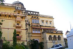
| Pratapgarh - Devgarh Palace | ||
Pratapgarh ( Hindi : प्रतापगढ़ Pratāpgaṛh ; formerly Partabgarh ) is a city with approximately 45,000 inhabitants in the Indian state of Rajasthan in a predominantly rural area with a high proportion of tribal population. Pratapgarh is the capital of the district of the same name . From 1689 to 1956 it was the center of the princely state of Pratapgarh .
location
Pratapgarh is located in southeast Rajasthan near the border with the state of Madhya Pradesh on the eastern edge of the Aravalli Mountains at an altitude of almost 500 m above sea level. d. M. The city of Chittorgarh is located approx. 110 km (driving distance) north; Udaipur is located about 175 km northwest. The climate is warm to temperate; Rain actually only falls during the summer monsoon months .
population
Official population statistics have only been kept and published since 1991. The strong increase in the urban population is mainly due to the immigration of families from the surrounding area.
| year | 1991 | 2001 | 2011 |
| Residents | 29,443 | 35,422 | 42,079 |
About 71% of the population are Hindus , just under 18% are Muslims and just under 11% are Jains ; other religions play no role among the rural population in large parts of India. They mostly speak Rajasthani and Hindi . As is usual in northern India, the male population is around 5% higher than the female; the literacy rate is just under 86%, making it one of the highest in all of India.
economy
Agriculture in the surrounding area is still the livelihood of the population; Traders, day laborers and all kinds of service providers have settled in the city itself.
history
The city ultimately emerged as a result of a brotherly dispute between the Maharajas of Chittorgarh in the 15th century: The first capital was Devgarh in the Aravalli Mountains, and Pratapgarh was only founded in 1698. From 1425 to 1949 it was the capital of a princely state that was also recognized by the British and retained great domestic political powers. After independence, however, it went on in the Indian Union.
Attractions
- Several historical city gates mark the border to the old town, whose narrow streets are worth a visit.
- Surroundings
- Approx. The Gautameshwar Temple, which is important for the region, is located 18 km south of the village of Arnaud .
- The old Prince's Palace is located in Devgarh or Devliya, 13 km away .
- Approx. 50 km east of Pratapgarh is the city of Mandsaur with an important Shiva shrine.
Others
Every Sunday there is a market in the city where the tribesmen of the surrounding villages sell their goods (including jewelry, etc.).
Web links
- Pratapgarh, Tourism - Photos + Info (English)

