
Aravalli Mountains
| Aravalli Mountains | |
|---|---|
 Location of the Aravalli Mountains |
|
 Udaipur in the Aravalli Mountains |
|
| Highest peak | Guru Shikhar ( 1722 m ) |
| location | Gujarat , Rajasthan , Haryana ( India ) |
| Coordinates | 25 ° N , 75 ° E |
The Aravalli Mountains are a multi-subdivided mountain range in northwest India . It runs in almost parallel strips over almost 600 km in a south-west-north-east direction from the extreme north of the state of Gujarat through all of Rajasthan to Haryana , where it gradually merges into the Ganges Basin .
geography
The orogeny of the Aravalli Mountains took place about two billion years ago in the Proterozoic . The strongly rugged mountains are divided into two subgroups: in the south are the higher Sambhar-Sirohi Hills , in the north the flatter Sambhar-Khetri Hills , which are split into individual mountains . Geologically, it is a remnant of the oldest fold mountain range on the Indian subcontinent . Only a few peaks are higher than 1000 m; the highest point is the 1722 m high Guru Shikhar near the approx. 1150 m high city of Mount Abu . In addition, the Aravalli Mountains represent the climate and watershed between the Thar Desert in the west and the more fertile plains of Rajasthan to the east and south-east.
Lakes and rivers
The Aravalli Mountains are interspersed with smaller artificial lakes, mostly created centuries ago (e.g. Nakki Lake , Pichola Lake , Pushkar Lake , Man Sagar Lake ), which in earlier times ensured the drinking water supply. There are no larger rivers in the mountains (only the Sabarmati River has its source in the Udaipur district , but later flows through the plains of southern Rajasthan and Gujarat ); Streams only form in the monsoon season (July to October) when the water flows down the mountain flanks, where most of it seeps away or evaporates.
Cities
The Aravalli Mountains are characteristic of the Indian state of Rajasthan: During the 15th and 16th centuries. Most of the mountain forts were built on its peaks in the 19th century , so in the following years almost all larger cities in eastern Rajasthan ( Jaipur , Udaipur , Jodhpur , Chittorgarh , Kota , Bundi ) were built in the valley. The cities of the Shekhawati region in northeastern Rajasthan are only slightly influenced by the Aravalli Mountains.
Mining
Since the Aravalli Mountains are rich in natural resources , mining is carried out several times , including illegal ones. This contributes to the erosion of the mountains, which in turn accelerates the expansion of the Thar desert and threatens the water supply of Rajasthan.
Culture
The Aravalli Mountains are rich in cultural treasures: In addition to the numerous mountain forts and palaces of the Rajput princes, the Jain temples of Ranakpur , Mount Abu and Achalgarh should be mentioned . Medieval Hindu temples can be found in the fort of Chittorgarh as well as at Nagda and Eklingji ; the Pushkar Lake in Ajmer is one of the most important Hindu -Heiligtümer India.
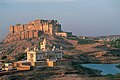
Meherangarh Fort, Jodhpur

Temple in Chittorgarh Fort

Victory Storm at Chittorgarh Fort

Man Sagar Lake and Jal Mahal near Jaipur

Adinath Temple in Ranakpur


