
Presqu'île (Lyon)


The Presqu'île de Lyon (German: "Peninsula of Lyon") is a district of Lyon and is located in the 1st and 2nd arrondissement of Lyon . The peninsula was added to the UNESCO World Heritage List in 1999 .
etymology

In Roman times the square was called Canabae or the island of the Canabae, after the Latin canaba (pl: canabae) . This term is generally used for a Roman city quarter in which the trading posts are located. Trade in Lugdunum, the ancient "Lyon", took place mainly on the river. So it came about that the name Canabae was associated with the district of the peninsula. The name is evidenced by two Roman inscriptions:
- A stone block on the Rue Clotilde-Bizolon in the 2nd arrondissement : this base (1.69 m high, 0.7 m wide) was erected in honor of their master by wine merchants who lived in this canabae .
- In November 1809 a large fragment was found in the Saône which read: "[-] ian [-] negotiatores v] inari (i) C [abanenses]" (the wine merchants of the Canabae district ).
The term "presqu'île" has only been used in French since 1546.
Location description

le Palais de la Bourse in the Cordeliers district
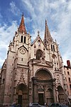
The Église St-Nizier

The Hôtel-Dieu de Lyon , hospital (former hospital)
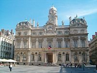
The town hall

The Fontaine Bartholdi on the Place des Terreaux

The Musée des beaux-arts de Lyon , (Palais Saint-Pierre)


geography
The peninsula is oriented from north-southeast to east-northwest and is 4.5 km long. It is located between the districts of Terreaux , La Croix-Rousse and La Confluence . It is about 650 to 700 meters wide on average, with the maximum width of 830 m in the La Confluence district and only 570 m in the Cordeliers district . It is surrounded by the Saône in the west and the Rhône in the east. The peninsula now includes the center of Lyon, the Perrache district and extends to the hills of La Croix-Rousse. Here is the longest pedestrian street in Europe: Rue de la République (banks, numerous grocery stores, fashion boutiques, cinemas, breweries and restaurants), Rue Mercière (in the center of the peninsula) and Place Bellecour (one of the largest squares in Europe with many events).
sociology
The peninsula is characterized by different social structures in its different quarters. There are four zones from north to south:
- The densely populated areas of Saint-Nizier, Terreaux and Cordeliers
- The Jacobin quarter and its golden square, where many luxury boutiques are located. The Place Bellecour is a pivotal point in the organization of the peninsula.
- In the Ainay district , Lyon's bourgeoisie traditionally meets around the Basilique Saint-Martin d'Ainay .
- The Lyon Perrache train station forms a historical border with the Perrache district , which was primarily an industrial district until the end of the 20th century.
- Finally, the Sainte-Blandine district and Avenue Charlemagne . This neighborhood is currently being redesigned following the “ La Confluence ” project .
Hydrology
Archeology, thanks to the excavations and with the help of geographers, geomorphologists and sedimentologists, managed to trace the topography through the centuries:
- In the Bronze Age , the alluvial plain of the Rhone was stable, as evidenced by the traces of the dwellings found on the left bank.
- At the beginning of the Iron Age (800-450 BC) hydrological activity was very high: the presence of gravel banks deposited at the foot of the Fourvière (now the Saint-Jean district ) shows that the confluence towards Saint- Paul has moved. The subsurface of the peninsula shows large gravel banks, which are separated from one another by 10 to 20 m wide and one to two meters deep channels: In geomorphology , branches are known that arise from the constant shifting of the course of the river. - The peninsula was therefore uninhabitable at the beginning of the Iron Age.
- In the second part of the Iron Age (450 to 50 BC) a change was announced: the peninsula was a plain with floods. The level was raised with each flood of sand and silt. The canals gradually filled up. The Rhone shifted to the east and the Saône left its bed at the foot of the Fourvière and shifted it to the place visible today. The peninsula was created. The confluence shifted to the east and stabilized in the south of what is now the Ainay district .
- When the Roman settlement from 43 BC The peninsula was roughly the same as it is today, except that the residential corridors are no longer flooded during high water. The peninsula was therefore only from the 1st century BC. Inhabited.
history
Roman times
The current peninsula corresponds roughly to what various historians call île des Canabae . The existence of the peninsula is confirmed from the 1st century BC. Confirmed, although with each flood several new islands arise. It can be assumed that the peninsula was created by the interventions of the population who had settled along the Saône and Rhône. There are many hypotheses about the topographical development of the peninsula.
middle Ages
In the Middle Ages and the Renaissance , merchants and printing shops settled in Rue Mercière , the heart of the peninsula, and ensured a lively life. In the 21st century, it was mainly brewery restaurants that settled here and ensured that the street's attraction continued.
Renaissance
The shopping axis of the peninsula runs along the current streets and squares of Rue Mercière , Place des Jacobins (formerly Place Confort), Rue Confort and Rue Bellecordière.
Breakthrough in the 19th century
Following the example of Paris and its great boulevard Haussmann , the great axis was also created in Lyon during this period: rue Victor Hugo and rue de la République (later rue Impériale).
The peninsula is connected to the Croix-Rousse plateau by two funiculars : Funiculaire de la rue Terme from 862 and Funiculaire de Croix-Paquet (today Ligne C du métro de Lyon ) from 1891.
20th century
today
The peninsula is the historic heart of the city and is now the central business district. The sales of the shops on the peninsula can compete with those of the commercial center of Part-Dieu ( 3rd arr. ).
Attractions
Today the peninsula is the actual center of Lyon. It is the urban continuation of the ancient city, of Vieux-Lyon (Middle Ages and Renaissance) with its renaissance streets ( Rue Mercière ), the great veins in the Haussmann style, the squares, the town villas and classical buildings. It is a UNESCO World Heritage Site . Here is a compilation of some remarkable structures:
- Saint Martin d'Ainay basilica
- Place Bellecour with the equestrian statue of Louis XIV and a statue of Antoine de Saint-Exupéry with " the little prince "
- Antonin-Poncet square
- Carnot square
- Hôtel-Dieu
- Theater of the Celestins
- Lyon Stock Exchange
- Église Saint-Nizier de Lyon
- Lyon City Hall and Place des Terreaux
- Fine Arts Museum
- Opera

Statue on Place Bellecour of Louis XIV.

Plan for the design of the peninsula from 1863

The theater of the Celestins


Transport links
The peninsula is easily accessible, especially by metro.
More information
- 1st arrondissement (Lyon)
- 2nd arrondissement (Lyon)
- www.lyon.fr/
- www.rhonetourisme.com
- www.mypresquile.com/
Individual evidence
- ↑ CIL 13, 1954
- ↑ CIL 13, 1788
- ↑ Le petit Robert 2007
- ^ Collective under the direction of Mathieu Poux and Hugues Savay-Guerraz: Lyon avant Lugdunum . In: Infolios éditions . 2003, p. 29 .
- ^ Collective under the direction of Mathieu Poux and Hugues Savay-Guerraz: Lyon avant Lugdunum . In: Infolios éditions . 2003, p. 30 .
- ↑ Grégoire Ayala: Evolution d'un bord de Saône de l'Antiquité à nos jours: la fouille du parc Saint-Georges, bilan préliminaire . Ed .: Revue archéologique de l'Est. Lyon 2007, p. 153-185 . ; read on the page: RAE
- ↑ For example, the archaeologist Amable Audin , Essai sur la topographie de Lugdunum
- ↑ Peninsula and floods in the 1st century BC Chr.
- ↑ A summary of these hypotheses can be found here (in French).
- ↑ A metro map can be viewed here.
Coordinates: 45 ° 45 ′ N , 4 ° 50 ′ E