Puerto Iguazú

|
||
| Basic data | ||
|---|---|---|
| Surface: | 766 km 2 | |
| location | 25 ° 37 ′ S , 54 ° 35 ′ W | |
| Height above d. M .: | 162 m | |
| Population (2001): | 32,038 | |
| Density: | 42 inhabitants / km² | |
|
|
||
| administration | ||
| Province : |
|
|
| Department : | Iguazú | |
| Founding: | August 12, 1901 | |
| Mayor: | Claudio Raúl Filippa | |
| Others | ||
| Postal code : | N3370 | |
| Telephone code: | +54 (3757) | |
| Website of Puerto Iguazú | ||
| map | ||

|
||
Puerto Iguazú is a small town founded in 1901 on the Triple Frontera , the three-country triangle between Argentina , Brazil and Paraguay .
geography
location
The city is located in the Argentine province of Misiones at the confluence of the Río Iguazú in the Río Paraná . The small town is known mainly because of the Iguaçu waterfalls ( Cataratas de Iguazú ) located about 18 kilometers away in the adjacent national park area.
City structure
The urban area is divided into three parishes: the parishes of Virgen del Carmen (parish of the bishopric of the diocese of Puerto Iguazú ), Christo Redentor and San Roque González .
Culture and sights
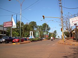
The main source of income for the city is the tourism business . The cityscape in the center and at the entrance to the town is characterized by numerous hotels and restaurants . Outside the immediate center, the tourist impression gives way to an average, sometimes impoverished provincial townscape.
Besides the national park and the waterfalls, the tourist attraction of the place is the viewpoint tres hitos ("three boundary stones"). This point offers a panoramic view over the confluence of the Iguazú in the Paraná and thus over the adjacent banks on the Paraguayan or Brazilian side. Each of the three banks is also marked with an oversized boundary stone in the national colors.
climate
|
|||||||||||||||||||||||||||||||||||||||||||||||||||
The climatic area is subtropical. There is no dry season. The annual average temperature is around 24 ° C.
traffic
The city is connected via the airport, which is about ten kilometers away . The international bridge Puente Internacional Tancredo Neves connects the Argentine highway Ruta National 12 (connection with the provincial capital Posadas , approx. 250 km south) with the Brazilian BR-469 (connection to the Brazilian neighboring city Foz do Iguaçu , approx. 15 km north).
Town twinning
There are city partnerships with the two neighboring cities in the border triangle, Ciudad del Este in Paraguay and Foz do Iguaçu in Brazil.
Web links
- Official Website: http://iguazu.gob.ar/
proof
- ↑ Portal des Misiones ( Memento of December 24, 2013 in the Internet Archive ), accessed on December 9, 2016
