Qau el-Kebir
Map of Egypt |
Qau el-Kebir (ancient Egyptian dschu qa "high mountain") is a village on the east bank of the Nile , about 45 km south of Assiut . There is the necropolis of Tjebu (Greek Antaepolis), the ancient capital of the 10th Upper Egyptian Gau : Wadjit . While tombs from all epochs of ancient Egyptian history have been discovered in Qau el-Kebir , it is best known for the tombs of the local Gau princes of the Middle Kingdom .
Research history
In the winter of 1905/1906 an Italian mission under Ernesto Schiaparelli dug in Qau el-Kebir; 1913/1914 a German mission (Hans Steckeweh, Georg Steindorff ); 1923/1924 a British under the direction of WM Flinders Petrie . Many of the finds from Qau el-Kebir are now in the Egyptian Museum in Turin .
The royal tombs of the Middle Kingdom
The four rock tombs of Qau el-Kebir are the largest known private graves of the Middle Kingdom (see also Assiut , Beni Hassan , Deir el-Bersche , Meir ). They consist of a valley temple , an access path, an upper temple and the actual burial chambers. The oldest grave is that of Ibu , who was Gaufürst under Amenemhet II or Sesostris I during the last years of the reign . His successor was Wahka I , who was also Gaufürst under Amenemhet II. His successor Nachti was buried in the tomb of Wahka II , who was born under Sesostris II or Amenemhet III. served. Wahka II followed Sobekhotep, who owned the smallest of the four graves. Under Amenemhet III. one stopped building monumental tombs in Qau el-Kebir. The following Gau princes are only known through seals . The rock graves that have been preserved are now badly damaged.
The grave of May , in which the remains of his sarcophagus were still found, comes from the New Kingdom .
The Ptolemaic Temple
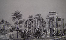
A temple for the local god Nemti in Antaepolis, which was built under Ptolemy IV , was dismantled at the beginning of the 19th century for the construction of a palace. The remaining remains were washed away by a flood in 1821. Engravings from the Description de l'Égypte still testify to its original state of preservation (see illustration).
literature
- Horst Beinlich : Qau el-Kebir, in: Lexikon der Ägyptologie , 5th vol., Wiesbaden 1984, column 48.
- Elvira D'Amicone: Qau el-Kebir (Antaeopolis), Dynastic Sites. In: Kathryn A. Bard (Ed.): Encyclopedia of the Archeology of Ancient Egypt. Routledge, London 1999, ISBN 0-415-18589-0 , pp. 652-54.
- Wolfram Grajetzki : Comments on the mayors (HAtj-a) of Qaw el-Kebir in the Middle Kingdom, Göttinger Miszellen 156 (1997), pp. 55–62.
- Wolfram Grajetzki: The Middle Kingdom of Ancient Egypt: History, Archeology and Society , London 2006, 97-102.
- Naguib Kanawati: The Governors of the wADt-nome in the Old Kingdom, in: Göttinger Miszellen 121 (1991), pp. 57-67.
- WM Flinders Petrie : Antaeopolis. The Tombs of Qau (British School of Archeology in Egypt 51), London 1930.
- Richard Pietschmann : Antaiupolis . In: Paulys Realencyclopadie der classischen Antiquity Science (RE). Volume I, 2, Stuttgart 1894, Col. 2343 f.
- Hans Steckeweh : The princely graves of Qaw (publications of the Ernst von Sieglin Expedition 6), Leipzig 1936.
Web links
- Extensive presentation on Qau el-Kebir on the website of the Petrie Museum of Egyptian Archeology (London)
- Information on Qau el-Kebir on Su Bayfield's website
Coordinates: 26 ° 54 ' N , 31 ° 31' E

