Quadrant (Antarctica)
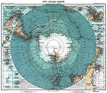
The Antarctic continent is schematically divided into four quadrants ( Latin quadrans = quarter), each 90 degrees of geographical longitude wide Antarctic sectors , which are based on the prime meridian :
The four quadrants were originally proposed by the British geographer Clements Markham in 1899 as the first rough breakdown and designation of large regions of the Antarctic continent, which was largely unexplored at the time:
| No. | Western border |
East border |
Quadrant ( English ) |
German | Remarks |
|---|---|---|---|---|---|
| 1 | 90 ° E | 180 ° | Victoria Quadrant | Victoria Quadrant | in it was the well-known Viktorialand |
| 2 | 180 ° | 90 ° W | Ross Quadrant | Ross Quadrant | in honor of James Ross , who at that time had penetrated the furthest into the region |
| 3 | 90 ° W | 0 ° | Weddell Quadrant | Weddell Quadrant | in honor of James Weddell , who had penetrated furthest south here, with the Antarctic Peninsula |
| 4th | 0 ° | 90 ° E | Enderby Quadrant | Enderby Quadrant | after the Enderbyland in the region, which was already sighted around 1831 |
The only known land mass in the Roß Quadrant at that time was Peter I Island, which was discovered in 1821 and 450 kilometers off the mainland coast of Antarctica .
Frederick Cook suggested that the four quadrants should be based on the continents north of them :
- Australian quadrant ( Australian Quadrant )
- Pacific Quadrant ( Pacific Quadrant )
- American Quadrant ( American Quadrant )
- African quadrant ( African quadrant )
The name Pacific Quadrant alone did not derive its name from a continent, since further north of this quadrant (or north of the Southern Ocean defined in 2002 , as far as it falls in this quadrant) there is no continent, but the Pacific Ocean .
The Antarctic quadrants were always listed in clockwise order from west to east, in contrast to the quadrants in the Cartesian coordinate system .
This rough breakdown should also serve to coordinate the exploration of the continent by Germany, England, Scotland and Sweden, who had planned larger expeditions for the period between 1901 and 1904 at the turn of the century:
- Gauss expedition (1901–1903, first German Antarctic expedition)
- Discovery Expedition (1901–1904, first English, actually British, Antarctic expedition)
- Swedish Antarctic Expedition (1901–1903)
- Scottish Antarctic Expedition (1902–1904)
The results of these expeditions were then summarized by Adolphus Greely in 1907 according to these quadrants, using the names suggested by Frederick Cook.
The German names were first published in 1908 by Ludwig Mecking (1879–1952), including the Viktoria quadrant with k and Roß quadrant explicitly with a sharp ß , but in the fourth quadrant instead of Enderby quadrant , Gauss quadrant , named after the German expedition ship Gauß .
Isaiah Bowman (1878–1950) named the first quadrant (Weddell or American Quadrant) Atlantic Quadrant in 1930 .
The quadrant structure of the Antarctic continent is still used in scientific publications until very recently (1993).
Individual evidence
- ↑ Bernadette Hince: The Antarctic Dictionary. A Complete Guide to Antarctic English. , P. 281.
- ^ Clements Markham: The Antarctic Expeditions. In: The Geographical Journal. Vol. 14, No. 5 (Nov. 1899), pp. 473-481.
- ^ Edwin Swift Balch: Antarctic Names. In: Bulletin of the American Geographical Society. Vol. 44, No. 8 (1912), p. 564.
-
↑ Adolphus Washington Greely: Handbook of Polar Discoveries. Boston 1907:
- Chapter XX: The African Quadrant (pp. 278–284)
- Chapter XXI: The Australian Quadrant (pp. 285-297)
- Chapter XXII: The Pacific Quadrant (pp. 298-300)
- Chapter XXIII: The American Quadrant (pp. 301-312)
- ↑ Ludwig Mecking: The current state of the geography of the Antarctic. In: Geographical Journal. 14, No. 8, 1908, pp. 427-447.
- ^ Isaiah Bowman: Antarctica. In: Proceedings of the American Philosophical Society. Vol. 69, No. 1, 1930, p. 40.
- ↑ Stephen D. Cairns (Ed.): Biology of the Antarctic Seas XXII. (= Antarctic Research Series). Amer Geophysical Union, 1993, ISBN 0-87590-826-8 , p. 127.

