Sector (Antarctica)
A sector of the continent of Antarctica is a region or part of this continent in a geographical sense. In the literature, the effort to achieve a division or partitioning of the southern and northern polar regions into geographical units in the form of circular sectors (" pie pieces ") is referred to as the sector principle or theory ( English sector principle, sector theory ). designated.
In contrast to some other geographical sectors, the definition of such units of Antarctica touches on several content areas or geographic subject areas, u. a. the Geodesy and political geography .
Geographical classification
Geographical place names -or. information
Island or coast
The first positioning on the continent took place in 1821. Fabian Gottlieb von Bellingshausen named two islands in front of and on the Antarctic Peninsula , on January 10th Peter I Island and January 28th Alexander I Island . This was followed by Jules Dumont d'Urville in 1840 with the name of the discovered Côte de Clarie .
coast
From 1840 onwards, like the Côte de Clarie ( see tables below ), other stretches of coast were given names:
- 35 from the mainland,
- 12 of the Antarctic Peninsula and
- 6 on the inner Ross Sea ,
Thus, names were available for the entire coastline of the Antarctic mainland. The inland beginning of the boundaries between the individual coastal sections is in the US Board on Geographic Names. The US Geological Survey is expressed in angular measurements (with an accuracy of degrees and minutes of arc ). This allows a definite place in the geographical latitude and longitude of the earth. There was only overlap in the naming of the Берег Правды by the USSR in the 1950s on the earlier proclaimed Kaiser Wilhelm II coast of the country of the same name.
For this purpose, the terms Russian Берег , English Coast , French Côte and Norwegian Kyst were used in the respective national languages equivalent to the German-language content of coast. The coast of the Côte de la terre Adélie borders the Côte de Clarie , where JD d'Urville also landed. This became the Terre Adélie , the sector of French territorial claims.
country
The third of the large groups of place names or indications are countries, such as the just mentioned Terre Adélie or Adelieland. Here the equivalents are called Russian Земля or French Terre .
Although proclamations of territorial claims were rare in the 19th century, a trend began for expeditions that the Antarctic expeditions were not only out to discover, but also aimed at the formal takeover of the lands they had discovered.
sector
Clements Markhams Sectors
The oldest division of the continent into sectors is based on four sectors with an angle of 90 ° each . These district districts are also quadrants and accordingly the geographical units of this division are called Antarctic quadrants .
The British geographer Clements Markham, among others, proposed such a division of the country, his partitioning dates from 1899.
Ocean sector
For sciences, for example zoology , a division of the waters around Antarctica took place based on the respective adjacent oceans . The Pacific is between 130 ° East 50 ° West and the Atlantic and Indian Ocean sectors accordingly between 50 ° West and 130 ° East. The figures differ by ± 10 °. The indicator part extends z. B. depending on the literary sources from 60 ° to 90 ° East and from 60 ° to 100 ° East.
Sector ≤ 90 °
Further division proposals followed the concept of the four 90 ° sectors or quadrants. This reduced (apart from the larger part of the Australian Antarctic Territory ) the angular dimensions of the circular sectors to less than 90 °. Bounded in the west and east by selected longitudes , the units converged at the geographic south pole . In both divisions, sectors with 90 ° or less than 90 °, the center of the circle is the south pole. This is therefore a multi-country corner, namely a four-country corner with a 90 ° division model and a multi-country corner of a higher degree with more than four sectors, each with an angle of less than 90 °.
Political geography
historical overview
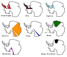
From 1908 several states began to formulate territorial claims for parts of the continent of Antarctica. These national claims (with the exception of Peter I Island , which is claimed by Norway ) are several sectors of the circle, ie “pieces of cake”, the number of which varies with the number of claimants. In the literature, terms such as "pieces of cake" u. Ä. to find ( English pie slices , pie pieces or pie-shaped sectors bounded by meridians ). The Australian Antarctic Territory consists of two sectors separated by the French claimed Adélieland . The British, Chilean and Argentine sectors largely overlap.
Due to the Antarctic Treaty, national territorial claims south of the 60th parallel have been suspended since it came into force on June 23, 1961.
Tables
Stretches of coast
| Surname | Location |
|---|---|
| Antarctic Peninsula (east coast): | |
| Nordenskjöld Coast | 58 ° 50'-61 ° 01'West |
| Oscar II Coast | 61 ° 01′-62 ° 37′W |
| Foyn Coast | 62 ° 37′-65 ° 16′W |
| Bowman Coast | 65 ° 16'-62 ° 56'W |
| Wilkins Coast | 62 ° 56'-61 ° 23'W |
| Black Coast | 61 ° 23'-59 ° 54'W |
| Surname | Location |
| Antarctic Peninsula-Palmerland (east coast): | |
| Lassiter Coast | 59 ° 54'-62 ° 20'W |
| Orville Coast | 62 ° 20′-69 ° 40′W |
| Zumberge Coast | 69 ° 40 '' - 78 ° 30'W |
| Antarctic mainland (east coast): | |
| Prince Regent Luitpold Coast |
36 ° -27 ° 54'W |
| Caird Coast | 27 ° 54'-20 ° W |
| Crown Princess Märtha Kyst |
20 ° West– 5 ° East |
| Princess Astrid Kyst | 5 ° –20 ° East |
| Princess Ragnhild Kyst |
20 ° -34 ° E |
| Prins Harald Kyst | 34 ° -40 ° E |
| Crown Prince Olav Kyst | 40 ° -44 ° 38′E |
| Kemp Coast | 56 ° 25′-59 ° 34′E |
| Mawson Coast | 59 ° 34′-66 ° 54′E |
| L. Christensen Kyst | 66 ° 54'-71 ° E |
| I. Christensen Kyst | 72 ° 33′-81 ° 24′E |
| Leopold and Astrid Kyst | 81 ° 24′-87 ° 43′E |
|
Берег Правды K. Wilhelm II Coast |
88 ° –100 ° E 87 ° 43–91 ° 54 ' |
| Queen Mary Coast | 91 ° 54′-100 ° 30′E |
| Knox Coast | 100 ° 31′-109 ° 16′E |
| Budd Coast | 109 ° 16′-115 ° 33′E |
| Sabrina Coast | 115 ° 33′-122 ° 05′E |
| Banzare Coast | 122 ° 05′-130 ° 10′E |
| Cote de Clarie | 130 ° 10′-136 ° 11′E |
| Côte de la terre Adélie (Côte Adélie) |
136 ° 11′-142 ° 02′E |
| George V Coast | 148 ° 02′-153 ° 45′E |
| Oates Coast | 153 ° 45′-164 ° 09′E |
| Pennell Coast | 164 ° 09′-170 ° 14′E |
| Borchgrevinkkysten | 170 ° 14′-165 ° 25′E |
| Scott Coast | 165 ° 25'-169 ° E |
| Surname | Location |
|---|---|
| Antarctic Peninsula (west coast): | |
| Davis Coast | 59 ° 24'-61 ° 02'West |
| Cote de Danco | 61 ° 02'-63 ° 47'W |
| Graham Coast | 63 ° 47'-65 ° 53'W |
| Cote Loubet | 65 ° 53'-67 ° 05'W |
| Cote Fallières | 67 ° 05'-68 ° 51'W |
| Antarctic Peninsula Palmerland (West Coast): | |
| Rymill Coast | 68 ° 51'-66 ° 47'W |
| English Coast | 66 ° 47'-79 ° 45'W |
| Surname | Location |
| Antarctic mainland (west coast): | |
| Bryan Coast | 79 ° 45′-89 ° 35′W |
| Eights Coast | 89 ° 35′-103 ° 24′W |
| Walgreen Coast | 103 ° 24'-114 ° 12'W |
| Bakuti's Coast | 114 ° 12′-127 ° 35′W |
| Hobbs Coast | 127 ° 35′-136 ° 50′W |
| Ruppert Coast | 136 ° 50′-146 ° 31′W |
| Saunders Coast | 146 ° 31'-158 ° 01'W |
| Shirase Coast | 157 ° 54'-151 ° W |
| Surname | Location |
|
Inner Ross Sea ( Ross Dependency ): |
|
| Siple Coast | 151 ° -≈153 ° W |
| Gould Coast | ≈153 ° W-168 ° |
| Amundsen Coast | 168 ° -167 ° 22'W |
| Dufek Coast | 167 ° 22'W.-172 ° 45 ' |
| Shackleton Coast | 172 ° 45′-160 ° 45′E |
| Hillary Coast | 160 ° 45′-169 ° E |
| Connection see Scott Coast | |
See also
literature
- US Board on Geographic Names. US Geological Survey, Reston.
Individual evidence
- ^ Charles Bourel de La Roncière and G. Clerc-Rampal: Histoire de la marine française . Volume 5. Larousse. Paris, 1934, p. 244.
- ^ Noël Mamère: Report d'Information sur l'Arctique et l'Antarctique. Assemblée nationale Paris, 2015, p. 139.
- ^ Donald Rothwell: The Polar Regions and the Development of International Law . Cambridge University Press, Cambridge 1996, ISBN 0-521-56182-5 , p. 53.
- ^ GP Glasby: Antarctic Sector of the Pacific. Elsevier Science Publishers, Amsterdam 1990, ISBN 0-444-55566-8 , p. 11.
- ↑ PP Shirshov Institute of Oceanology of the Academy of Sciences of the USSR. 27. American Geophysical Union, 1987, p. 222.
- ↑ Francesco Francioni, Tullio Scovazzi: International Law for Antarctica. Kluwer Law International, The Hague 1997, ISBN 90-411-0364-3 , p. 643.
- ^ Adrian John Howkins: Frozen Empires: A history of the Antarctic sovereignty dispute between Britain, Argentina, and Chile, 1939-1959 . University of Texas at Austin, Ann Arbor 2008, p. 58.
- ^ John Hobbie Roscoe: American Force Manual, regional photo interpretation series, Antarctica (AFM 200-30). US Department of the Air Force, 1953.
- ^ Suzanne Lalonde, Ted L. McDorman: International Law and Politics of the Arctic Ocean. Brill, Leiden 2015. pp. 216ff. ISBN 978-90-04-28458-6 .
Web links
- Map: Sector breakdown of the Arctic ( Memento from May 18, 2017 in the Internet Archive )


