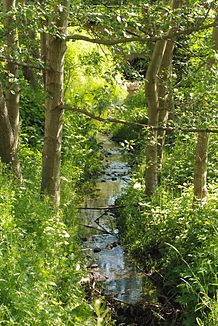
Rahlau
| Rahlau | ||
|
The Rahlau in Tonndorf (Wilsonstrasse) |
||
| Data | ||
| location | Hamburg , Germany | |
| River system | Elbe | |
| Drain over | Wandse → Alster → Elbe → North Sea | |
| source | North of Tonndorf 53 ° 35 ′ 29 ″ N , 10 ° 8 ′ 21 ″ E |
|
| muzzle | In Wandsbek in Wandsetwiete coordinates: 53 ° 34 '53 " N , 10 ° 5' 59" O 53 ° 34 '53 " N , 10 ° 5' 59" O
|
|
| Left tributaries | Langenbek, Deepenbrookgraben (filled in) | |
| Big cities | Hamburg | |
The Rahlau is a brook in the Hamburg city area. It rises north of Hamburg-Tonndorf on the border with Rahlstedt and flows into the Wandse in Wandsbek .
course

The Rahlau climbing the Dora in Tonndorf
In its lower reaches, the Rahlau was canalised parallel to the Wandse. From 2004 it was renatured there by a group of artists and conservationists and later by the German Nature Conservation Union (NABU) and now serves as a fish path for the dammed Wandse.
The Rahlau forms the border between Jenfeld and Tonndorf. It flows through or touches the areas of the following districts of Hamburg:
Web links
Commons : Rahlau - Collection of images, videos and audio files
Individual evidence
- ↑ Michael Bergemann: Complete list of flowing waters in the Elbe catchment area . Authority for the Environment and Energy, Hamburg July 1, 2015 ( fgg-elbe.de [PDF; 802 kB ; accessed on November 29, 2015]).
- ^ Christian Rasch: Stadtfluss Wandse Project / Position Bypass. Hamburg, 2004
