Washington Pass
![]() Map with all coordinates: OSM | WikiMap
Map with all coordinates: OSM | WikiMap
| Washington Pass | |||
|---|---|---|---|
|
The hairpin bend on State Route 20 to Pass and Liberty Bell Mountain as seen from State Route 20 (east) in the Methow River Valley |
|||
| Compass direction | west | east | |
| Pass height | 1669 m | ||
| region | Chelan / Okanogan County , Washington (State) , USA | ||
| Watershed | Tributary of the Skagit River | Methow River ( Columbia River ) | |
| Valley locations | Diablo, Chelan County (Washington) | Winthrop, Okanogan County (Washington) | |
| expansion | Washington State Route 20 | ||
| Built | 1972 | ||
| Winter closure | November – April | ||
| Mountains | northern cascade range | ||
| Map (Washington) | |||
|
|
|||
| Coordinates | 48 ° 31 '28 " N , 120 ° 39' 27" W | ||
| Rainy Pass | |||
|---|---|---|---|
|
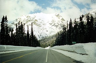
Rainy Pass in spring |
|||
| Compass direction | west | east | |
| Pass height | 1486 m | ||
| region |
Chelan County / Skagit County , [[Washington
(State)]], United States |
||
| Watershed | Tributary of the Skagit River | ||
| Valley locations | Diablo, Chelan County (Washington) | ||
| expansion | Washington State Route 20 | ||
| Built | 1972 | ||
| Winter closure | November – April | ||
| Mountains | northern cascade range | ||
| Map (Washington) | |||
|
|
|||
| Coordinates | 48 ° 31 ′ 2 ″ N , 120 ° 44 ′ 3 ″ W. | ||
Washington Pass (5477 feet / 1669 m above sea level) and Rainy Pass (4875 feet / 1486 m above sea level) are two neighboring mountain passes that crossed from west to east in the northernmost part of the Cascade Range of the Washington State Route 20 highway become. Rainy Pass is about seven kilometers west of Washington Pass. As the name "Rainy Pass" suggests, the cascade range is extremely rainy; Because of the heavy snowfall (up to six meters) and the danger of avalanches, the road is closed in winter. As a connection from the west coast of Washington to the east into the catchment area of the Columbia River , the highway was not completed until late in 1972, before the passes were only used by Indians and trappers .
At Rainy Pass, the north-south long-distance hiking trail crosses the highway. In 1978, a short spur road, the Washington Pass Overlook Trail, was built north of Washington Pass to a lookout point. From here one overlooks the Liberty Bell Mountain range and the course of the highway to the east. The Washington Pass is also the starting point for access to the climbing routes at the Liberty Bell.

Individual evidence
- ↑ Washington Pass Overlook Trail. American Trails, April 24, 2013, accessed April 11, 2018 .
Web links
- Washington Pass on the United States Geological Survey's Geographic Names Information System —Washington Pass
- Rainy Pass in the Geographic Names Information System of the United States Geological Survey — Rainy Pass
- Pass road conditions from WSDOT


