
Ranfjord
| Ranfjord | ||
|---|---|---|
| Waters | European Arctic Ocean | |
| Land mass | North Helgeland , Norway | |
| Geographical location | 66 ° 14 ′ N , 13 ° 36 ′ E | |
|
||
| length | 67 km | |
| Islands | Dønna , Løkta , Finnkona , Hugla , Feøya , Bardalsøy , Strømholmen | |
| Tributaries | Ranelva , Røssåga | |

The Ranfjord is a Norwegian fjord in North Helgeland . The fjord lies in the area of the municipalities of Nesna , Vefsn , Hemnes and Rana .
The 68 km long fjord runs east-northeast from the island of Dønna to the town of Mo i Rana . The inner section is wider and the waterfront areas are more fertile and wooded there than in the outer part. At the height of the Hemnes peninsula, the narrow Skarpsundet sound connects the main fjord with two southern arms, the Sørfjorden and the Elsfjorden . Part of the European route 6 and the Nordlandsbanen run along the inner fjord .
On the fjord in Mo i Rana few kilometers from the start Mo i Rana, Røssvoll from the European route E12 , which to the Finnish Helsinki leads.
In Mo i Rana the 130 km long Ranelva flows into the sea, and at the end of the southern Sørfjorden the 50 km long Røssåga .
Islands
There are the following larger islands in the Ranfjord in the east-northeast:
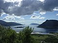
View of the outer fjord near Nesna
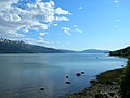
View from the north - between Båsmoen and Alteren
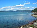
End of the fjord at Mo i Rana
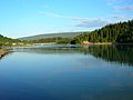
Mouth of the Ranelva


Web links
Individual evidence
- ↑ a b Store Norske Leksikon: Ranfjorden , accessed on September 13, 2010 (Norwegian)