Rastavica
|
Rastavica / Rastavicë 1 Rastavica / Раставица 2 |
||||
|
||||
| Basic data | ||||
|---|---|---|---|---|
| State : |
|
|||
| District : | Gjakova | |||
| Municipality : | Deçan | |||
| Coordinates : | 42 ° 30 ′ N , 20 ° 20 ′ E | |||
| Height : | 498 m above sea level A. | |||
| Residents : | 1,238 (2011) | |||
|
1 Albanian (indefinite / definite form) , 2 Serbian (Latin / Cyrillic spelling) 3 Kosovo's independence is controversial. Serbia continues to regard the country as a Serbian province. |
||||
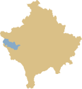
Rastavica ( Albanian also Rastavicë , Serbian Rastavica Раставица) is a village in the municipality of Deçan in western Kosovo .
geography
The village is located on the national road 107 and lies between the two large cities of Peja and Gjakova .
population
The village has 1238 inhabitants, all of whom call themselves Albanians , except for six people who call themselves Bosniaks .
history
Rastavica is a Slavic form of the village. The village was conquered by the Ottomans from 1454 and Islamization took place. Rastavica was replaced by the Ottoman Empire in 1910 , but they came to the Kingdom of Montenegro for eight years when the Kingdom of Yugoslavia (Kraljevsto Srba, Hrvata i Slovenaca) was founded. Rastavica was a battleground during the Kosovo war . In 2008 the Republic of Kosovo was founded . Today the village is mainly characterized by agriculture. Mayor in 2020 was Rexhë Kadrijaj.
Individual evidence
- ↑ Agjencia e Statistikave të Kosovës |. Retrieved April 11, 2020 .


