Rathenauplatz (Frankfurt am Main)
| Rathenauplatz | |
|---|---|
| Place in Frankfurt am Main | |
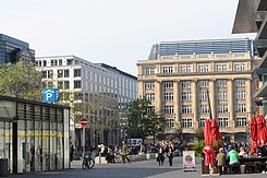
 View from Roßmarkt over Goetheplatz to Rathenauplatz |
|
| Basic data | |
| place | Frankfurt am Main |
| District | Downtown |
| Created | middle Ages |
| Newly designed | 2008 |
| Confluent streets |
Kalbächer Gasse , Börsenstrasse, Biebergasse, Steinweg Goetheplatz , Goethestrasse |
| Buildings | Comoedienhaus (1782–1904) |
| use | |
| Space design | Pedestrian zone |
| Technical specifications | |
| Square area | 4000 m² |
The Rathenauplatz is a square in the city center of Frankfurt am Main . It goes south into Goetheplatz . Both were originally part of the Roßmarkt established in the Middle Ages . The northern part of the Roßmarkt has been called Comoedienplatz or Theaterplatz since 1780 , after the city theater built by Johann Andreas Liebhardt in 1780 and demolished in 1904. During the Weimar Republic , the square was named after the Reich Foreign Minister Walther Rathenau, who was murdered by nationalist and anti-Semitic terrorists in 1922 . During the Nazi era from 1933 to 1945 it was called Horst-Wessel- Platz .
The Rathenauplatz is, with the exception of the carriageway running on its west side, a pedestrian zone. Three streets lead into the square: from the north the Börsenstrasse , from the east the Biebergasse and from the west the Kalbächer Gasse , which is generally only known by its dialect name Freßgass . In the south, the Rathenauplatz borders the Goetheplatz . This part of the Roßmarkt got its name in 1844 when Ludwig Schwanthaler erected the Goethe monument here . The transition between the two squares is formed by the connecting line between the Steinweg , which joins from the east, and the Goethestrasse, which leads west .
The perimeter block development is characterized by monumental Wilhelminian style buildings , which were rebuilt after war damage and partly renovated and rebuilt in the 1990s, as well as commercial buildings in the simple style of the reconstruction period of the 1950s.
Under the Rathenauplatz, tunnels of the Rhein-Main S-Bahn run between the Hauptwache and Taunusanlage stations and the U6 and U7 underground lines between Hauptwache and Alte Oper . From 1952 to 1986, with an interruption during the tunnel construction from 1969 to 1976, there were tracks of the city tram on the square , which were used by line 12.
literature
- Fried Lübbecke : The face of the city. Based on Frankfurt plans by Faber, Merian and Delkeskamp 1552–1864 . Waldemar Kramer Verlag, Frankfurt am Main 1983, ISBN 3-7829-0276-9 .
Web links
- City Planning Office ( Memento from April 30, 2010 in the Internet Archive )
- Current plan
- The Roßmarkt at altfrankfurt.com
Coordinates: 50 ° 6 ′ 50 ″ N , 8 ° 40 ′ 36 ″ E