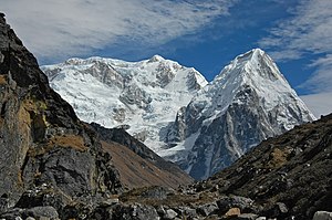
Rathong
| Rathong | ||
|---|---|---|
|
Rathong from Sikkim |
||
| height | 6682 m | |
| location |
Taplejung ( Nepal ), West Sikkim ( India ) |
|
| Mountains | Kangchenjunga Himal ( Himalaya ) | |
| Dominance | 2.77 km → Kabru (South Summit) | |
| Notch height | 312 m ↓ ( 6370 m ) | |
| Coordinates | 27 ° 35 '39 " N , 88 ° 5' 20" E | |
|
|
||
| First ascent | October 29, 1964 by an Indian army expedition | |
|
Kabru South and Rathong from Nepal |
||
The Rathong (or Ratong ) is located in the Himalayas on the border between Nepal in the west and the Indian state of Sikkim in the east.
The summit is 13.4 km south-southwest of the eight-thousander Kangchenjunga . To the northeast, a mountain ridge leads to the 7,317 m high south summit of the Kabru . In the south, the Rathong La mountain pass separates the Rathong from the 6148 m high Kokthang .
Ascent history
The first ascent of the Rathong was made by members of an Indian army expedition (Nawang Gombu, Captain Ahluwalia and the Sherpas Dorje Lhatoo and Ang Kami) on October 29, 1964. The following day, Tashi, Sonam Wangyal, Sonam Gyatso, Captains Bahuguna, Cheema and Joshi and Harish Rawat reached also the summit.


