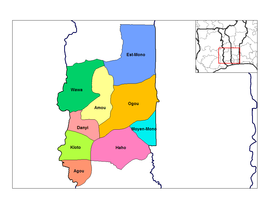
Plateaux region (Togo)
| Plateaux | |
|---|---|
| Basic data | |
| Capital : | Atakpamé |
| Area : | 16,975 km² |
| Residents : | 1,375,165 (census, 2010) |
| Population density : | 81.01 inhabitants / km² (census, 2010) |
| ISO 3166-2 : | TG-P |
Plateaux is a region of Togo with the capital Atakpamé .
geography
The region is located in the central south of the country and borders the Centrale region in the north, the Maritime region in the south, Ghana in the west and Benin in the east .
Localities
The most important towns are Kpalimé , Kloto , Badou and Notsé .
Other locations:
- Akoba
- Amou Oblo
- Ana
- Anié
- Coura
- Fogo
- Garbadé
- Gléi
- Haito
- Issati
- Lapa
- Lomba
- Mata
- Médjé
- Mora
- Nuatia
- To do
- Toliun
- Touro
- Yanda
Administrative division
The region is divided into the following prefectures:
| prefecture | location | Administrative headquarters |
| Agou (prefecture) | W. | Agou-Gadjepe |
| Amou (prefecture) | N, central | Amlamé |
| Danyi | SW | Danyi apéyémé |
| Est-Mono | NO | Elavagnon |
| Haho | S. | Notsé |
| Kloto | W. | Kpalimé |
| Moyen Mono | SO | Tohoun |
| Ogou (prefecture) | O | Atakpamé |
| Wawa (prefecture) | NW | Badou |


