Rehberg (Wutha-Farnroda)
| Rehberg | ||
|---|---|---|
|
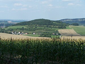
View from the south of the Rehberg |
||
| height | 368.4 m above sea level HN | |
| location | Wutha-Farnroda in Thuringia ( Germany ) | |
| Mountains | Waltershäuser Vorberge → Thuringian Basin (with edge plates) | |
| Coordinates | 50 ° 56 '43 " N , 10 ° 24' 5" E | |
|
|
||
| rock | Red sandstone | |
The Rehberg is a partially forested mountain in the east of the Wartburg district in Thuringia , its height is 368.4 m above sea level. HN . The mountain is made of red sandstone.
The clearly recognizable corridor boundary of the districts Farnroda and Wutha (border ditch, old boundary stones) runs over the mountain . On the southern slope of the mountain, by a spring that has now been buried, lies the medieval desert of Berzigeroda, marked by a striking oak in the field until 1995. Most of the mountain was owned by the Farnrodaer estate; the eastern part was owned by the Rehhof farm belonging to Wutha .
The Rehberg, which was completely cleared in the Middle Ages, still shows many arable terraces, especially on the south side. A nameless spring rises on the north side of the mountain, on the north-east side there is a now wooded gorge, it leads to the valley in the direction of Rehhof. An old road with a connection to the Rennsteig runs past the southern flank of the mountain .
From 1985 the northern slope was designated as the construction site for the Wutha-Mölmen prefabricated housing estate. The "Rehbergsiedlung" belonging to Farnroda was built on the south-west slope as early as the 1920s; it is currently being expanded significantly (mostly single houses) by a housing program of the Thuringian state development company. The ski hut on Rehberg is reminiscent of a ski jump located there.
literature
- Illustrated books Wutha-Farnroda Volumes I – IV . Geiger, Horb am Neckar 1991, 1992, 1997 and 2003, ISBN 3-89264-596-5 , ISBN 3-89264-706-2 , ISBN 3-89570-284-6 and ISBN 3-89570-859-3 .
Individual evidence
- ↑ Official topographic maps of Thuringia 1: 10,000. Wartburgkreis, district of Gotha, district-free city of Eisenach . In: Thuringian Land Survey Office (Hrsg.): CD-ROM series Top10 . CD 2. Erfurt 1999.

