Reisach (Höttingen)
|
Reisach
community Höttingen
Coordinates: 49 ° 5 ′ 34 ″ N , 11 ° 2 ′ 18 ″ E
|
|
|---|---|
| Height : | 445 m above sea level NN |
| Residents : | 21st |
| Incorporation : | May 1, 1978 |
| Postal code : | 91798 |
| Area code : | 09141 |
|
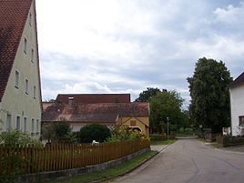
Center of Reisach
|
|
Reisach is a district of the municipality of Höttingen in the central Franconian district of Weißenburg-Gunzenhausen .
The hamlet is located on a plateau between Ettenstatt and Mischelbach , near the village of Kemnathen and the Arbach river , around 4 km from Höttingen. There are several springs nearby, and the Blümleinskreuz wayside cross is 300 m from the hamlet.
To the north of Reisach there was a Neolithic and Latène period settlement, and to the south there were probably other settlements.
Until the municipal reform in Bavaria , Reisach was part of the formerly independent municipality of Fiegenstall . In 1978 both places were incorporated into Höttingen.
A side street connects Reisach with the neighboring towns of Walting and Fiegenstall .
Architectural monuments
Architectural monuments in the village are the single-storey farmhouse Reisach 5 with a gable roof and half-timbering from the 18th or 19th century and the single-storey farmhouse Reisach 3 with a saddle roof and plastered half-timbering from the 18th century.

