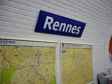
Rennes (Paris Metro)
|
|
|
|---|---|

|
|
| Tariff zone | 1 |
| Line (s) |
|
| place | Paris VI |
| opening | November 5, 1910 |
Rennes is an underground station on line 12 of the Paris Métro .
location
The metro station is located in the Notre-Dame-des-Champs district in the 6th arrondissement of Paris . It lies alongside the Boulevard Raspail between the Rue du Cherche-Midi and the Rue de Rennes.
Surname
The station is named after the Rue de Rennes. Rennes is located in the north-west of France at the mouth of the river Ille in the Vilaine . The city with around 213,000 inhabitants is the capital of the Brittany region and the seat of the prefecture of the Ille-et-Vilaine department .
history
The station opened on November 5, 1910, when the Société du chemin de fer électrique souterrain Nord-Sud de Paris (North-Sud) put the first section of its line A from Porte de Versailles to Notre-Dame-de-Lorette into operation . On March 27, 1931, line A was renamed line 12 after the Nord-Sud had been absorbed by the previously competing Compagnie du chemin de fer métropolitain de Paris (CMP) the previous year .
During the mobilization at the beginning of the Second World War , the station was closed. It was one of the nine underground stations that did not go back into operation after the war ended. It was only reopened on June 23, 1968, but was still not served on Sundays and public holidays or after 8 p.m. On September 6, 2004, the usual opening times of the metro stations were reintroduced there at the request of residents.
description
Under an elliptical , white tiled vault, there are two side platforms on two main tracks. In contrast to the stations set up by the CMP, the side walls do not follow the curvature of the ellipse, but run vertically in the lower area. Because of the overhead line originally on the north-south routes , the station is slightly higher than the CMP stations located under similar vaults. It has the original Parisian standard length of 75 m, sufficient for five-car trains.
The subway stations in the north-south were designed more elaborately than the stations of the CMP, but the Rennes station is now much simpler. Typical for the north-south are the remaining directions MONTMARTRE and MONTPARNASSE above the respective tunnel mouth. The only access is in the median of the Boulevard Raspail at its intersection with the Rue de Rennes. It largely corresponds to the original, the NORD-SUD logo was replaced by METROPOLITAIN in the early 1930s.
Although line 12 crosses metro line 4 of the former CMP immediately south of Rennes station , no direct transfer to the nearby Saint-Placide underground station was created at this point.
vehicles
On line 12, trains of the north-south type Sprague-Thomson ran initially , which differed in several points from the Sprague-Thomson vehicles of the CMP. A striking feature was the power supply of the leading railcar by means of a pantograph . After the takeover of Nord-Sud by CMP, this type of business was given up in the 1930s. In the 1970s, the north-south trains were eliminated in favor of the Sprague-Thomson standard design, and in 1977 modern trains of the MF 67 series came onto the line.
Web links
literature
- Gérard Roland: Stations de métro. D'Abbesses à Wagram . 2003, ISBN 2-86253-307-6 .
Individual evidence
- ^ Jean Tricoire: Un siècle de métro en 14 lignes. De Bienvenüe à Météor . 2nd Edition. La Vie du Rail, Paris 2000, ISBN 2-902808-87-9 , p. 294 .
- ↑ a b Jean Tricoire: op. Cit. P. 295.
- ^ Gérard Roland: Stations de métro d'Abbesses à Wagram . Christine Bonneton, Clermont-Ferrand 2011, ISBN 978-2-86253-382-7 , pp. 183 .
- ^ Brian Hardy: Paris Metro Handbook . 3. Edition. Capital Transport Publishing, Harrow Weald 1999, ISBN 1-85414-212-7 , pp. 36 .
| Previous station | Paris metro | Next station |
|---|---|---|
|
Sèvres - Babylone ← Front Populaire |
|
Notre-Dame-des-Champs Mairie d'Issy → |
Coordinates: 48 ° 50 ′ 53 " N , 2 ° 19 ′ 40" E

