
Retterschwanger valley

The Retterschwanger Tal is an alpine valley in the Oberallgäu district , traversed by the Bsonderach , a tributary of the Ostrach . It joins the Bad Hindelang district of Bruck with the Ostrach valley .
From the Horn Chapel in its lower part, the valley belongs to the Allgäu High Alps nature reserve . It is accessed via an alpine road that is not approved for public motorized traffic .
geography
It divides the thumb group of the Allgäu Alps into the higher eastern part, which leads from the Nebelhorn over the Großer Thumb to the Breitenberg , and the western, on the other side, sloping down to the Illertal, the chain of the Abschenkopf , Schnippenkopf , Heidelbeerkopf , Sonnenkopf , Strausberg, Imberger Horn . At the end of the valley under the Nebelhorn there is a weak pass to the Illertal, the Gängele (1847), over which a little-used alpine path runs. In the lower third of the valley, the Strausbergsattel provides a transition to Imberg and the Illertal.
history
The valley was first mentioned in documents in 1361. The mining and smelting of iron ore and its further processing in the region, which stretched from the 15th to the 19th century, had a strong influence on the image of the valley through the extraction of charcoal, which led to almost complete deforestation . There was also a small iron mine on the Hornbach. The only permanent settlement in the valley was the hamlet of Mitterhaus , where different owners ran horse breeding in the 16th and 17th centuries. With the decline in horse breeding Mitterhaus was in a Senn converted alp. In 1964, the Retterschwangtal nature reserve was set up, which is now part of the Allgäu High Alps NSG.
In 1990 hurricane Vivian destroyed large parts of the tree population, which after earlier deforestation was a spruce monoculture susceptible to windbreak.
photos

Horncafé

Horn Chapel
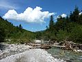
The Bsonderach between Horncafé and Mitterhaus


Web links
literature
- A. Vött: The natural features of the Retterschwanger Valley near Hindelang (Allgäu Alps) as a basis for evaluating its use in the cultural landscape. Geographer. Institute, Berlin 2000, DNB 962893145 . (Working reports of the Geographical Institute of the Humboldt University of Berlin 49)
Coordinates: 47 ° 27 ′ 51 ″ N , 10 ° 21 ′ 7 ″ E