
Rheinviertel
The term Rheinviertel stands for two different areas in Bonn . On the one hand, two residential areas in what is now the city district of Bonn were so named until the Second World War , to which a statistical district still goes back today. On the other hand, the term has been used since 2003 for a parish that includes several Bad Godesberg districts.
Bonn

Historically, the Rheinviertel was the residential area level with Bonn city center directly on the banks of the Rhine. The term "old town" was also used for these areas.
South of the Rhine Bridge, built in 1896–98 (predecessor of today's Kennedy Bridge ) to the Old Customs , there was a district that was originally inhabited by fishermen and customs officers and later became an urban residential area. The late Gothic Gertrudis Chapel, located at the lower end of Giergasse directly on the banks of the Rhine , a single - nave slate-roofed hall building with a three-sided choir and a six-sided turret with a curved dome was considered the center of the Rheinviertel . First mentioned in 1258, St. Consecrated to Gertrud von Nivelles and rebuilt around 1450, it was destroyed in the course of the siege of Bonn (1689) and rebuilt in 1699. The other buildings on the banks of the Rhine included the baroque “Mastiaux'sche Haus” at the end of the 19th century (from south to north) with an extension for the Prussian Mining Authority from 1830 (demolished in 1901–03 and replaced by the new Mining Authority building ), the Voigtstor as a house passage to Vogtsgasse, the Hotel Rheineck, which is inclined to the Rhine, and the two baroque city palaces of the Boeselager Hof with its two pavilions facing the banks of the Rhine on parts of the former city wall and the Metternicher Hof (demolished in 1904/06 and replaced by a five-storey historicizing Building complex of four to five houses replaced). At the Rhine end of the alley greed existed until its demolition in 1856 within the medieval walls that Giertor .
The so-called Kuhl , which stretched from the bank of the Rhine in a westerly direction to the collegiate church , had been located north of the later Rhine bridge or Brückenstrasse since the 19th century between Josefstrasse and Theaterstrasse . The workers in the factories in the north of Bonn lived here. The residential buildings were of poor quality. During the Weimar Republic, the Kuhl was a stronghold of the KPD and SPD . In the Judengasse (from 1886 on Tempelstrasse ) the new synagogue of the Jewish Community Bonn was built in 1879 , which was destroyed in the course of the November pogroms in 1938 .
The Rheinviertel was largely destroyed in the Second World War. It was decided not to rebuild the destroyed district on the existing street plan, but to raise the entire area of the Brassertufers two meters higher and completely rebuild it. The ruins of the destroyed buildings, often still with their outer walls - including the Gertrudis Chapel - were removed or filled in by the mid-1950s. A stylized city map in the Brüdergasse with the inscription "Altstadt-Umlassung 1944–1957" commemorates this reorganization of the Rheinviertel. 1944 stands for the heaviest air raid on Bonn on October 18, 1957 for the provisional completion of the new development. Among the striking buildings in the Rheinviertel south of Brückenstrasse, only the Oberbergamt, which was rebuilt in a slightly different form, remained. On the property of the former Nesselroderhof (today street Am Nesselroderhof with parking lot) there is a stele to commemorate the victims of the bombing and in memory of the old Rheinviertel. The term “old town” was then transferred to the inner northern part of the city from the mid-1970s .
Today, the Rheinviertel and Kuhl areas include the Bonn Opera (instead of the Boeselager Hof ), the Beethoven Hall , which rises from the rubble of the old town, and the Bonn Hilton Hotel . This stands on the site of the former main synagogue in Bonn, which was destroyed on November 9, 1938 . On the promenade in front of the hotel, a memorial commemorates the destroyed synagogue. In 2010/11, in the course of the construction of four eight-storey, box-like buildings with condominiums and commercial space, some buildings from the post-war development were demolished and - accompanied by archaeological excavations by the LVR Office for Land Monument Preservation in the Rhineland - the ruins of the Gertrudiskapelle and the Giertor excavated.
The name Rheinviertel is only used here today for the statistical district 110 Zentrum-Rheinviertel , which includes the bank south of the Kennedy Bridge and the entire part of the Zentrum district north of Bertha-von-Suttner-Platz .
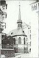
Gertrudiskapelle (around 1890)

Wall mosaic by the old town 1944–1957 in the Brüdergasse


bad Godesberg
Bad Godesberg, the Catholic concluded in 2003 parishes St. Evergislus and Holy Cross and St. Andrew and heart of Jesus to the Catholic Church community association Bad Godesberg-Rhine neighborhood together. The deed of establishment is dated December 9, 2003. On June 18, 2005, the new pastor of both parishes, Pastor Wolfgang Picken, founded the “ Bürgerstiftung Rheinviertel ”, a foundation for the private financing of church and social institutions in the Rheinviertel, which is under the supervision of the Archdiocese of Cologne. In 2006, the Rheinviertel parish association was dissolved again in the course of the merger of the two parishes. The "Catholic parish of St. Andreas and Evergislus in Bad Godesberger Rheinviertel" was created. The quarter is understood as the amalgamation of the northern parts of the city directly on the Rhine: Hochkreuz , Plittersdorf , villa district and Rüngsdorf . It extends north from the south bridge to the south of the Mehlem ferry and is bordered to the east by the Rhine and to the west by the B9.
literature
- Lothar Schenkelberg, Erhard Stang: Sightseeing flight over Bonn as it used to be . Wartberg Verlag, Gudensberg-Gleichen 2001, ISBN 3-8313-1115-3 .
- Simone Stein-Lücke, Thomas Schwitalla, congregation on the move. Self-help at the turn of the epoch with contributions by Udo di Fabio, Meinhard Miegel, Reinfried Pohl, Stephan Eilers and Wolfgang Picken, Bonn 2007, ISBN 978-3-416-03201-8
Web links
Individual evidence
- ↑ Schenkelberg and Stang, p. 28
- ↑ a b c d e f g Heijo Klein: Views from Bonn's banks of the Rhine . In: Bonner Heimat- und Geschichtsverein , Stadtarchiv Bonn (ed.): Bonner Geschichtsblätter. Yearbook of the Bonner Heimat- und Geschichtsverein , Volume 57/58, Bonn 2008, ISSN 0068-0052 , pp. 41–83.
- ^ Information board at the Women's Museum , Wikimedia Commons
- ^ Paul Clemen : The art monuments of the city and the district of Bonn . L. Schwann, Düsseldorf 1905, pp. 114–120 (= Die Kunstdenkmäler der Rheinprovinz , Volume 5, Section 3, pp. 410–416). (Unchanged reprint Verlag Schwann, Düsseldorf 1981, ISBN 3-590-32113-X ) ( Internet Archive )
- ^ A b c d e The destroyed Gertrudiskapelle and Bonn's Rheinviertel , film by Georg Divossen, Edition Rheinland im Film, Verlag & Medien Service, Sankt Augustin, ISBN 978-3936-253-80-1 .
- ↑ Schenkelberg and Stang, p. 12
- ↑ Bonn 1948/49: Everyday Life Before High Politics , Bonner Geschichtswerkstatt , accessed on October 23, 2016.
- ↑ Archaeologists uncover parts of the old Gertrudiskapelle , General-Anzeiger , April 14, 2010
- ↑ On the Brassertufer, Bonn's old town comes to life again for archaeologists , General-Anzeiger , August 26, 2010
- ↑ City map Bonn , map topic statistical districts in the Bonn area
- ↑ Official Journal for the Cologne District, Volume 184, No. 7, page 77 ( page no longer available , search in web archives ) Info: The link was automatically marked as defective. Please check the link according to the instructions and then remove this notice.
- ↑ Statutes of the Rheinviertel community foundation (§ 12 - Church bond) (PDF; 141 kB)