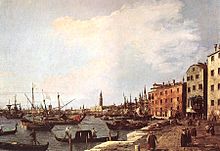
Riva degli Schiavoni
The Riva degli Schiavoni is considered to be one of the most important quays in Venice . It extends from St. Mark's Square eastwards to the Giardini pubblici. Five canals break through the Riva from the north. They are spanned by as many bridges. These bridges are quite high even by Venetian standards (up to 40 steps), so that the boats can cross under the bridges at any time even when the water level is high.
Even if the Riva can get very hot in summer, in winter it offers a place that is always warmed by the sun and that is considerably warmer than the adjacent streets. This is one of the reasons why it has long been the city's most important promenade.
Surname
It bears its name because the so-called Schiavoni (Venetian ethnonym for the numerous Slavs , mainly from Dalmatia, who immigrated to St. Mark's Town ) docked here with their goods, mostly meat and fish, from the 9th century. As Riva ( Italian : banks ) in Italian is also a border , that is a flat boat landing pad, respectively. This bank usually forms a promenade.
history
As early as the beginning of the 16th century, handicraft businesses such as glass furnaces and shipyards disappeared from the southern edges of Venice. In 1519 the Zattere, located west of the Grand Canal , were set up as a landing stage for boats and ships. The Riva degli Schiavoni may have been the model. In 1779/80 the expansion of the Riva was directed by Tommaso Temanza (1705–1789), who was an architect, hydraulic engineer and historian. In addition to residential buildings, there were also social facilities, such as the Ca 'di Dio, a home for old women.
The urge to expand the Riva culminated in a gigantic project in 1842. This year the city council set up a commission to collect proposals for the establishment of a municipal bath. One of the proposals was a hotel called Gran Albergo Cosmopolitano . It was to be built not far from St. Mark's Square and had cafes, billiard rooms, gaming rooms, 500 rooms, a casino, observatories, observation towers and reading rooms. The entrepreneur Giovanni Bussetto had the young architect Lodovico Cadorin create a design. The building would have spread out on the Riva, which was again extended by 70 m between Canale dell'Arsenale and the lead chambers . The city resisted the project because it would have deprived the trade of too much space, the ships of the landing stage, and the military of the opportunity to march through.
The fascists extended the Riva eastwards to the Giardini, where the Riva del Impero was created, with Impero the fascist empire that was meant to be created. It was initially to be named after Mussolini , today it is called Riva dei Sette Martiri after the opponents who were murdered there by fascists .
Even in the post-war period, the buildings on the Riva were dealt with extremely ruthlessly and against the resistance of the population. This applied, for example, to the extension of the Danieli towards the lead chambers. Between the Palazzo Dandolo, where the Danieli was located, and the prisons stood four modest buildings. This goes back to the fact that the Doge murderer Marco Casolo lived there in the 12th century, and therefore no palazzo was allowed to be built there. Norbert Huse called this type of building, like the one that Danieli had driven as a wedge into the Riva and demolished the four modest buildings, "barbarism".
Today the promenade is filled with numerous kiosks, bars and restaurants, which mainly attract tourists. From the Riva you have a southward view of the islands of the lagoon, especially San Giorgio Maggiore , then of the Dogana da Mar with its golden angel as well as of the Redentore Church and Santa Maria della Salute , the two buildings that thank you for the redemption were built by the most terrible waves of plague of the 16th and 17th centuries.
Web links
Individual evidence
- ^ Norbert Mappes-Niediek : Croatia. The land behind the Adriatic backdrop. 2009, p. 36.
- ^ Norbert Huse: Venice: From the art to build a city in water , Munich: Beck 2005, p. 189f.
- ↑ Norbert Huse: Venice: From the art of building a city in water , Munich: Beck 2005, p. 201.
Coordinates: 45 ° 26 ′ 1.8 ″ N , 12 ° 20 ′ 30.7 ″ E


